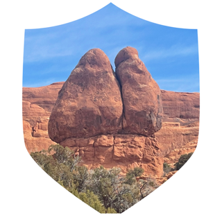
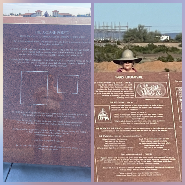
Getting our kicks on Route 66!
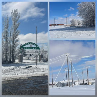
Day 29 – Wednesday – A casual drive from Chicago to home, less than 3 hours. It is sad to see it end but we can’t be on the road all of the time, right? RIGHT? 😊 The drive home was smooth and sunny. In fact, we didn’t really see any snow until we crossed over to Michigan and then most of what we saw were piles near driveways with much of the ground brown By Grand Rapids, we had snow along all the roads and some in the yards but by no means, would you say the snow covered the ground. The only picture for the day I think was what we called “The World’s Largest Martini”. 😊
While I have a knack for planning vacations, I can’t pretend to suggest that the fact that we finished our 7th book of the trip within 3 miles of our house was based on my knack. But it was impressive at the time, either way. To sum up the trip: 29 Days 7,482.5 miles 12 National Parks (10 new ones!) 6 State Parks and 1 National Wildlife Refuge.
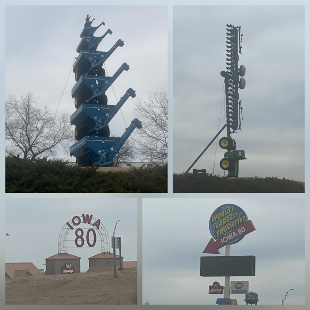
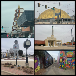
Day 28 – Tuesday – Todays drive we stopped to see a Tower of Grain Wagons, and we were rewarded as we drove around to the front of the company’s headquarters as not only did they have a Tower of Grain Wagons but they also had a large Tractor pulling a large implement behind it, straight into the ground! They say that good things come to those who search for silly stuff. It is worth noting that both displays were just outside the company’s “Innovation Center”. I think that says LOTS about what goes on inside that center. 😊 A few miles further down the road was the “World’s Largest Truck Stop”. Still amazing.
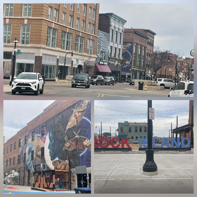
As we had lots of time, we drove into Davenport IA just to check it out. Nice small downtown area with some classic buildings located right on the Mississippi.
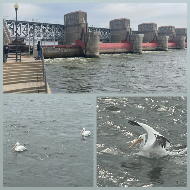
They have a dam & lock system and when we stopped to check it out, we saw the fish were running and 3 white pelicans were hoping to reel one in too!
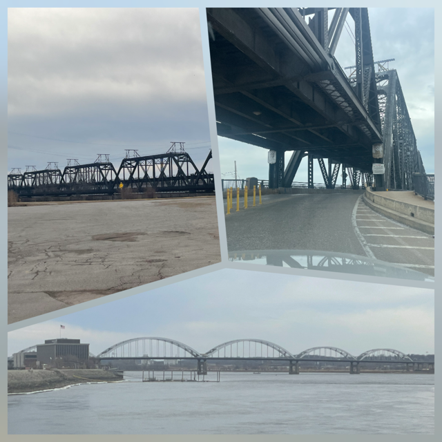
The bridge we chose to use to cross was a double decker with a train on the top and the cars driving on the level below. A cool train gizmo strikes again. On the other side was Rock Island, IL. I’m sure you remember the song, as soon as we saw the welcome sign we started singing. “Now, the Rock Island Line, she's a mighty good road...”. It is a smaller town, but their reconstruction efforts are working because it seemed reasonably busy for a Tuesday afternoon.
We are spending the night in Tinley Park, IL (southern subs of Chicago) because we didn’t really want to try that hard to get home AND I could get an Italian Beef for dinner. 😊
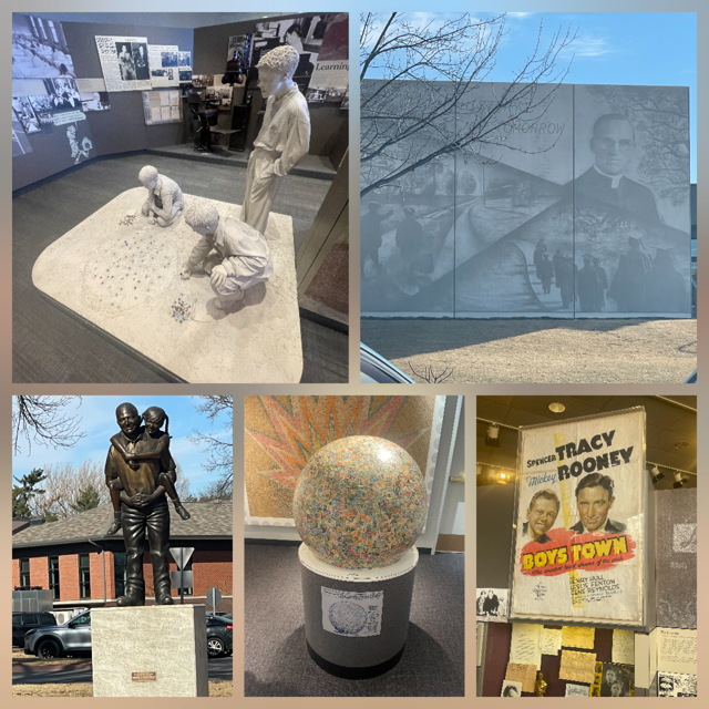
Day 27 – Monday – Before we left Omaha this morning, we had one more stop. Boys Town! Now if are not familiar with Boys Town it was founded in 1917 as Father Flanagan's Boys' Home. You might know it from the movie where Spencer Tracy won the Oscar and it co-starred Mickey Rooney. I must confess that while I was interested in its history (a little) it is also home to the World’s Largest Ball of Stamps! 😊I told Chris it would probably be a quick stop. As it turns out, we both enjoyed the museum and the grounds where we stayed nearly 2 hours!
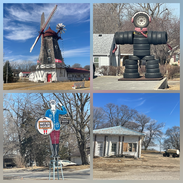
We left Omaha knowing today was only a 2+ hour drive to Des Moines so we could ‘explore’ if we wanted. First was the World’s Largest Corn Stalk (76 feet!).
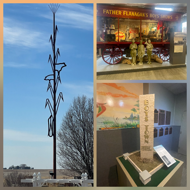
We continued down I-80 until we saw a sign, the only Danish Windmill in the US. Well, it was only 7 miles off the expressway, and it was the only one so off we headed to Elk Horn, IA. Instead of going back to the expressway, I suggested to Chris we just take the paved street in Elk Horn that headed east and, eventually, we would get back to I-80. Chris said “Go!”. Thank goodness we did or we would have missed the “tire guy” in some random small town. Not to be outdone, we then came across an old, not restored yet, gas station with a “White Rose Gasoline Guy”. The sign was in great shape.
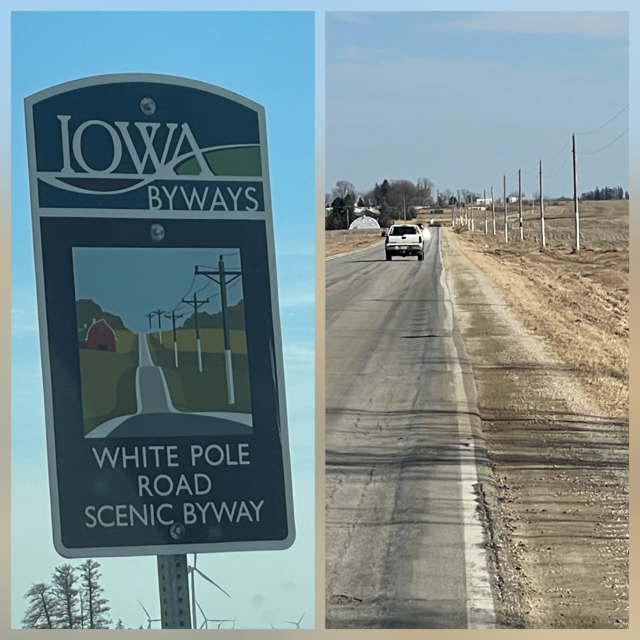
We continued on our expedition east, noticing that all the telephone poles had their bottom 6 feet painted white. It was a strange site and we couldn’t understand why? We have a running joke about Scenic Byways as we have been on dozens of them on this trip alone and what one state thinks is a scenic byway can be radically different from another state. So, when Chris said we were on the “White Pole Scenic Byway” I laughed at her joke. Then, a couple of miles down the road, I saw the sign. We WERE on the “White Pole Scenic Byway”! 😊
We went through one last town, Stuart, before getting back on I-80. Stuart had some very nice churches for a small town. We arrive in Des Moines and head straight for downtown and the state capitol. They have the only 5 dome capitol in the U.S. It was very impressive and the grounds around it were very classy. There was the capitol, some nice monuments, their state Supreme Court and all of it on a nice hill overlooking the town.
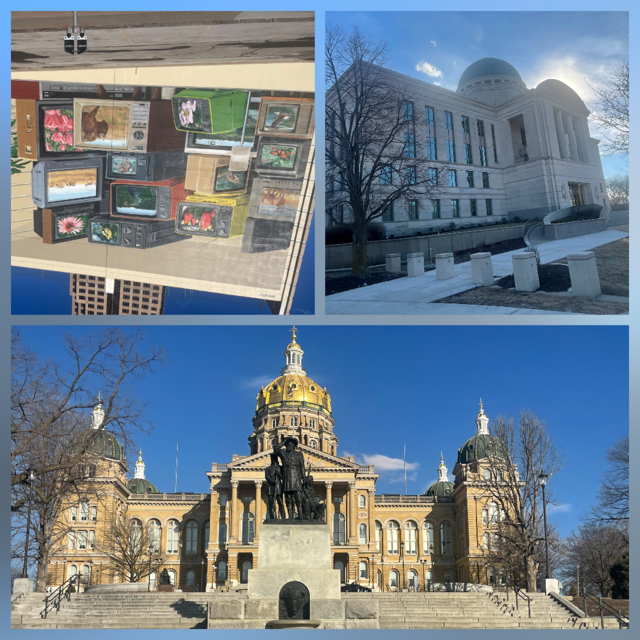
We drove through the downtown which had an old courthouse, new towers, a very cool “TV mural”, it seemed like a vibrant and interesting place. Before we went to our hotel, we stopped and did a quick load of laundry, in and out in less than 1 hour. Chris' friend, Liz grew up in Des Moines, so she gave us some possible stops. Unfortunately, the Herbert Hoover Presidential Library was closed for renovations. However the Brass Armadillo Antique Mall (HUGE!) and Smokey D’s BBQ were both open and her high recommendations were spot-on. As it turns out, Liz was in Des Moines visiting her parents so after our dinner and shopping, we went over and spent some time with the 3 of them. It was a great night.
Day 26 – Sunday – The drive today was just 3 hours to Omaha. The plan was to explore Omaha much like we have Joplin, Tulsa and Oklahoma City. Most of the drive today looked just like the drive yesterday – flat prairie or fields for a far as the eye can see. We did get see large flocks of Snow Geese in the fields around Kearney (they also migrate as far as Siberia or Greenland) as well as a few flocks of cranes so the drive wasn’t so bad.
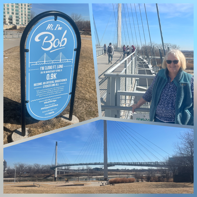
We arrived at the Bob Kerrey Pedestrian Bridge and took a walk. The bridge is over the Missouri River and between Omaha and Council Bluffs IA and 3,000 feet long. It is a nicely designed, curving suspension bridge. The weather was sunny in the mid-60’s so there were many people enjoying the bridge.
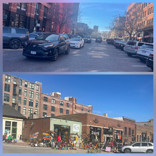
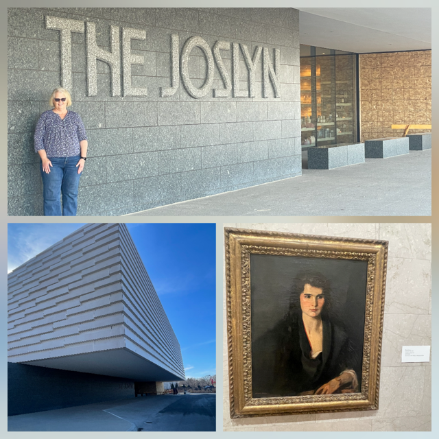
The city of Omaha is the home of Creighton University and a nice skyline.
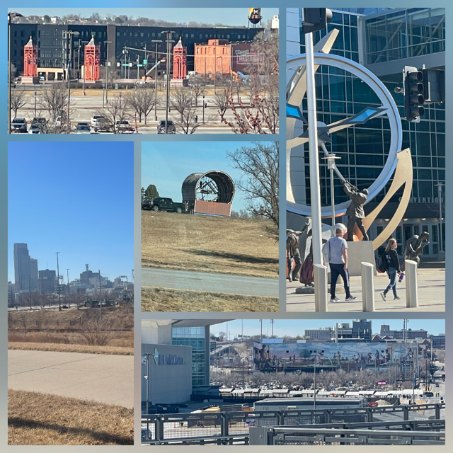
Next was the “Old Market” area of Omaha. It is a very cool old section of town with some of the streets looking like they belonged to the 1880s. I would definitely spend more time here next time and would recommend it as a place to visit for anyone driving through Omaha.
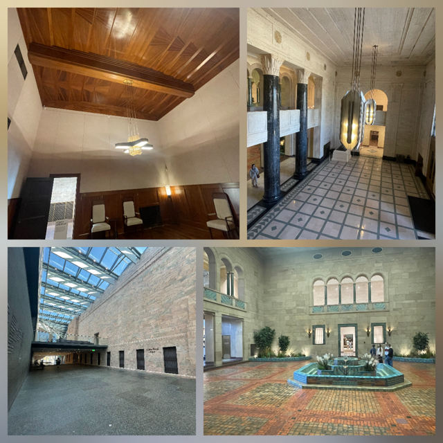
Joslyn Art Museum was on our list of places to visit. The exhibits were interesting and we were able to see 2 examples of Robert Henri. Why Henri? Simple, we saw an exit on I-80 that referred to his museum and gallery. We had to look him up and then, when we found ourselves at a museum, we specifically ask about him. 😊 The part of the museum I liked the best was the original building, built in 1931. It was astonishing!
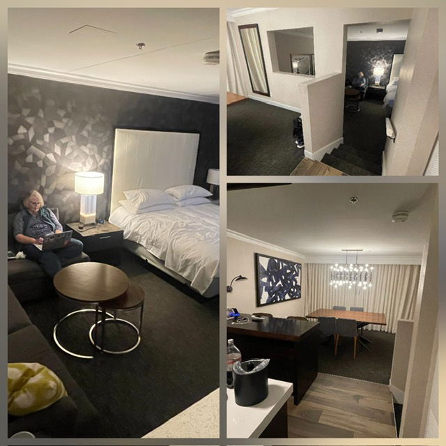
We finished the day off at Costco for gas and a few traveling essentials and then headed to the Omaha Marriott. Since I have lifetime status, I asked if they had an upgraded room for me and they did. We have a suite with a dining room, kitchenette on the upper level and then a King size bed with a big L shaped section sofa. Quite the place! The only bad part of the room is the 4 steps between levels. Who needs more stairs? 😊
Day 25 – Saturday – We finished our 6th book – Mitch Albom’s The Stranger in the Lifeboat: A Novel . Two thumbs up! Today’s drive was about 4 ½ hours to Kearney NE. The drive wasn’t the most scenic of the trip as the last hour of Colorado and 3+ hours of Nebraska are mostly flat, few trees, and miles and miles of either prairie or harvested wheat/straw. That said, the traffic was nearly non-existent, the road was so straight that a person could take a 5-minute nap and not have to worry the road curved (no, I did not!) It was mostly sunny so a pleasant drive.
Our first stop was Ogallala, NE. It was a boon as it offered up BOTH a water tower painted as a UFO (WITH an alien!), a restored 1922 Standard Oil service station AND a 12-foot-tall Cowboy sign for a frontier town!

Next up was North Platte. While it has similar gems as Ogallala, it had an even BIGGER draw: The Golden Spike Tower! A purposely built 8 story tower over the very best view of the world's largest railyard! Since it was Valentine’s Day, Chris’s gift to me was to let me go enjoy it alone, and she sacrificed by staying in the car, with the windows down, 60+ degrees and reading her book. Isn’t she great?!

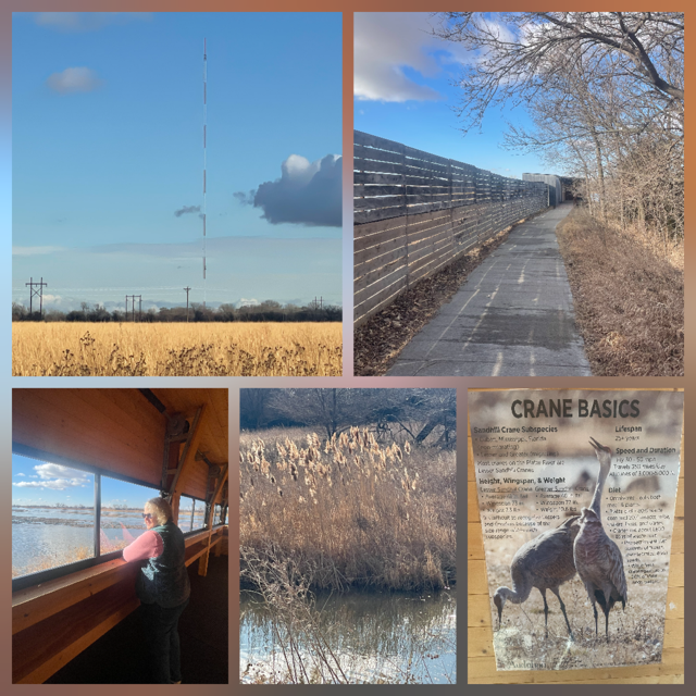
The primary target today was the Iain Nicolson Audubon Center at Rowe Sanctuary. A essential spot for watching the Sand Hill Crane migration. We knew we were 3 or 4 weeks early, but we wanted to learn more and see the “blinds” they use to view the migration. Every year over 600,000 cranes migrate through the Platte River valley. We did see one group in a field (probably 50+) and at the sanctuary you could hear them in the tall grass nearby all the time. The blind we visited was amazing. I talked to the person at the sanctuary about the small flock we had spotted earlier and they commented that some of the cranes actually migrate to Siberia and, maybe the ones we saw were getting an early start. 🤔
Last, after driving under it many times, we actually went to The Archway Museum (a large arch "museum" built over I-80). It was nicely done and as it was free for us (since we showed up 30 minutes before closing) we can highly recommend it. 😊
Happy Valentines Day to all!
Day 24 – Friday – There were three days of this trip that I was most concerned about travel conditions. Today was day 3 of the three days of travel I was most concerned about on this trip. You never know about weather but the past two days and today were the drives into the Colorado mountains and the snow can often close the roads or required chains and rental cars don’t come with chains. The last two days weren’t a problem but today the forecast was for rain/snow nearly the whole 6-hour drive (4 of it being east across the Rockies to Denver). Considering the drive time and potential weather issues, most of the day today was to be just in the car traveling across Colorado. Leaving our hotel this morning it was a mix of relatively hard rain and snow. We drove an hour north to Grand Junction and then headed east on I-70 and almost immediately, the rain stopped.
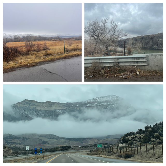
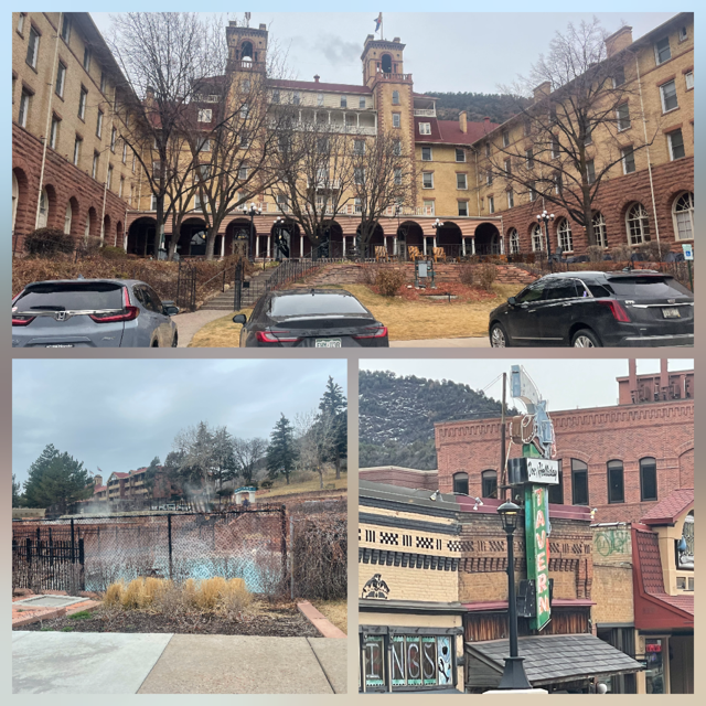
We kept our fingers crossed and as it turns out, the roads were dry, except for maybe 30 miles near the top pass and then it was just melting water here and there. Other than traffic getting busier near Denver, the drive was very good! Since the drive was going well, we stopped in Glenwood Springs to see the World’s Largest Hot Springs Pool and the historic downtown / lodge. It looked like a great town to spend a few days. Perhaps we will do this someday.
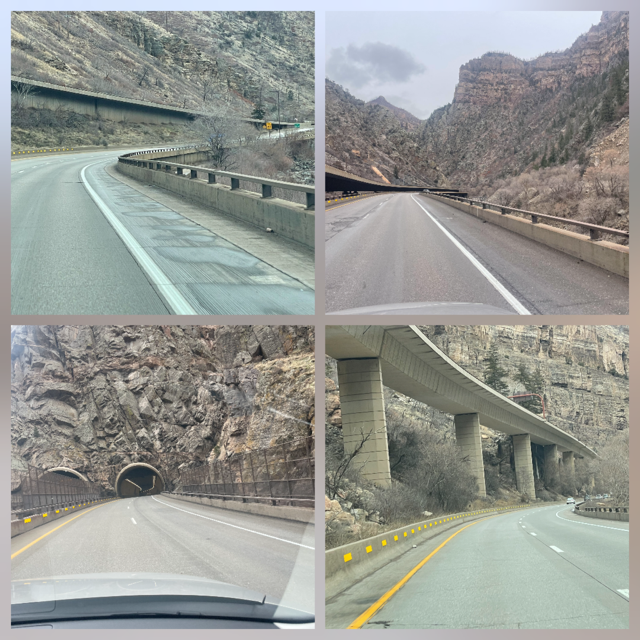
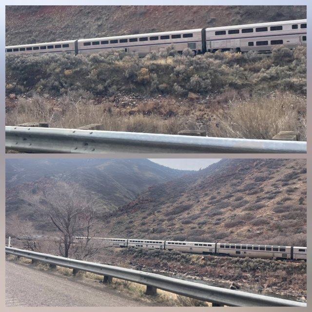
There were two cool things about today’s drive down I-70. First, we were driving down the same canyons we went through on Amtrak 20 years ago this summer. In fact, we even saw the Amtrak going through the valley (though it was headed east and when we rode it, we were going west). Secondly, we saw I-70 from the train as it goes through the Glenwood Canyon and I have always wanted to drive it. It is a 12.5-mile, engineering marvel completed in 1992, connecting Dotsero and Glenwood Springs. It features 40+ bridges, 3 tunnels (including the 4,000-foot Hanging Lake tunnels), and a tiered design built along the Colorado River. The scenic, $490 million project often requires closures due to rockfall, wildfires, or heavy rain. Thankfully, none of those things happened to us.
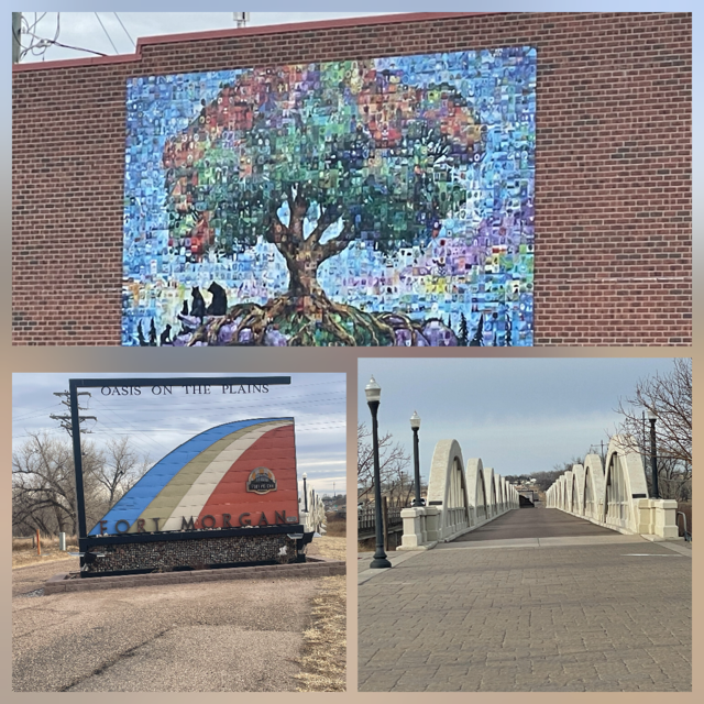
We are spending the night in Fort Morgan, home of the famous rainbow bridge.
Update: We rolled over the 6,000 mile mark.
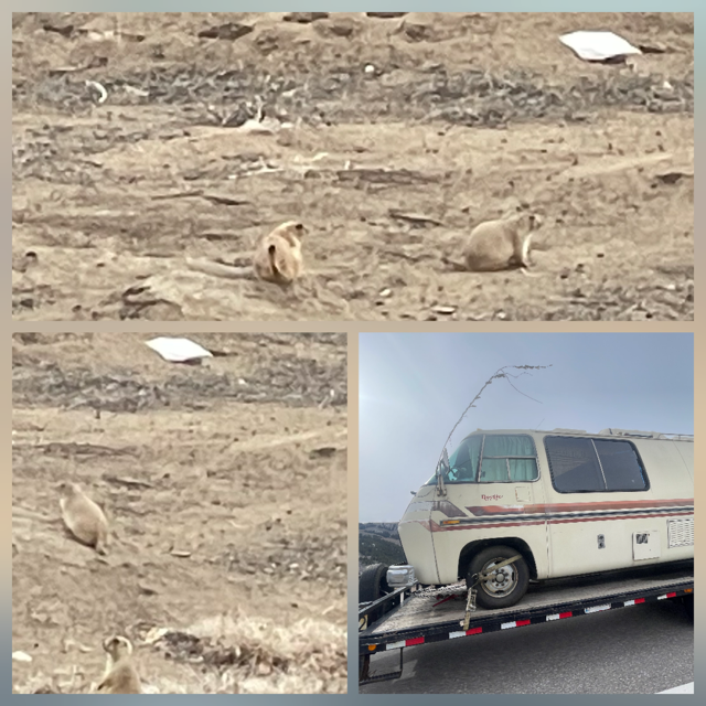
Sightings for today: Donkeys and a bald eagle on the bank of the Colorado River that we think was eating (sorry, no picture), a prairie dog colony and a classic 1970's GMC RV Motorhome (on a trailer) that we did not take a picture of the first time we passed it but then we got gas and passed it again so then we just had to the 2nd time.
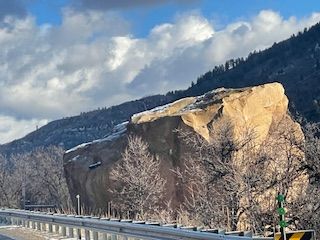
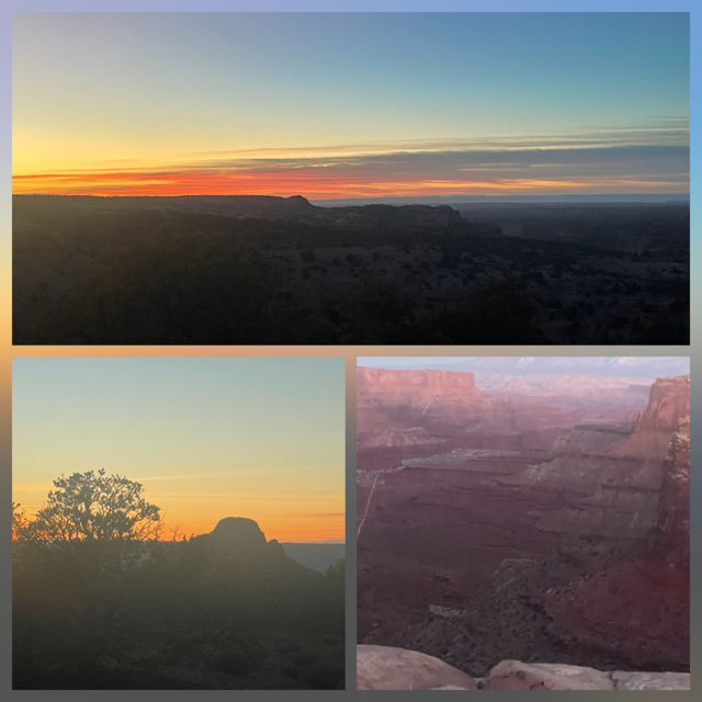
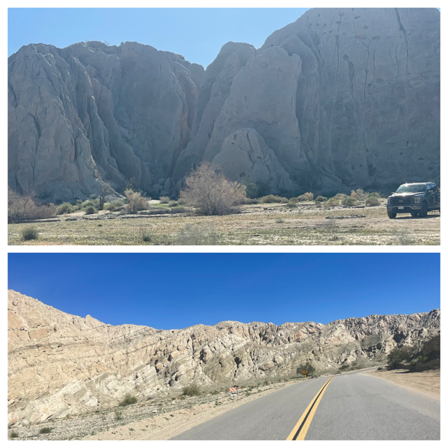
Day 23 – Thursday – Todays drive was to Black Canyon of the Gunnison National Park. Our 46th national park visited overall and our 10th new national park on this trip. But before we could do that, we had about a 4-hour drive. The first thing we wanted to see was “Memorial Rock – Boulder of Near Death”. On May 24, 2019 -- the start of Memorial Day Weekend -- an 8.5-million-pound sandstone boulder broke loose, rolled 1,000 feet down a hill, plowed a 15-foot-wide trench through Colorado Highway 145, and came to rest in a field on the other side. Even though Highway 145 is a heavily traveled road, no one was injured and only one vehicle was dented. As we drove along the highway, it was VERY OBVIOUS where the boulder sits today. (see below)

Our route took us within a few miles of the original mining town, now a ski town of Telluride, CO so we had to go see it. It was our first drive in snowy conditions; the roads were quite icy. As we were driving along Chris noticed across a small valley a cross-country skier with their dog trailing behind. Our first stop in Telluride is the Penny Bear. A 15-foot-tall bear ‘sculpture’ made by a couple using 187,000 pennies! It was very well done. The town of Telluride is very nice as its downtown is a historic district. They save the buildings (or at least the facades) so it looks great.

Like many tourist towns, Telluride offers free public transit. Unlike many tourist towns, their free transit is a gondola ride between Telluride and Mountain Village. Hey, free is always good so we found (and paid for parking) so we could take our free ride on the mountain. Great views and fun to watch the skiers below. We also saw the local airstrip on a butte where both ends of the runway have cliffs - which reminded us of a scene from a James Bond film. The ride takes you over the mountain by going up 1,750 feet to 10,500 feet and then down the other side 900 feet to Mountain Village. They built the gondola in 1996 to improve air quality by reducing the number of cars driving back and forth and it average 3.1 million riders a year. In addition, it is electrical and the power comes from wind farms!
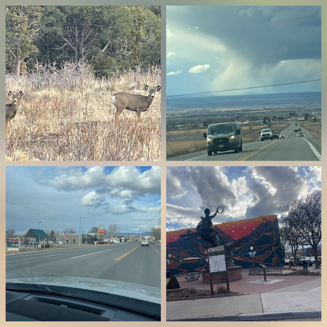
We arrived at Black Canyon of the Gunnison on schedule and headed to the visitor center and had the rangers to ourselves. As we drove into the park, the results of the 2025 fire were very apparent. We talked to the rangers about it and how things are progressing. They explained how much things have already started to rebound. With it being the winter AND because of the 2025 fire, the scenic road along the rim was mostly closed but there were some viewpoints open and they were worth the visit. The canyon plunges over 2,000 feet in many locations, with some sections measuring only 40 feet wide at the river level. As we left the park, we saw more dear and a hawk gliding just over ground level looking for dinner.
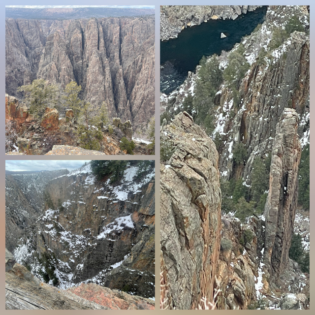
We are staying in Montrose, CO, just outside of the park and we were surprised at its size.
NOTE: Finished our 5th book of the trip today. :-)
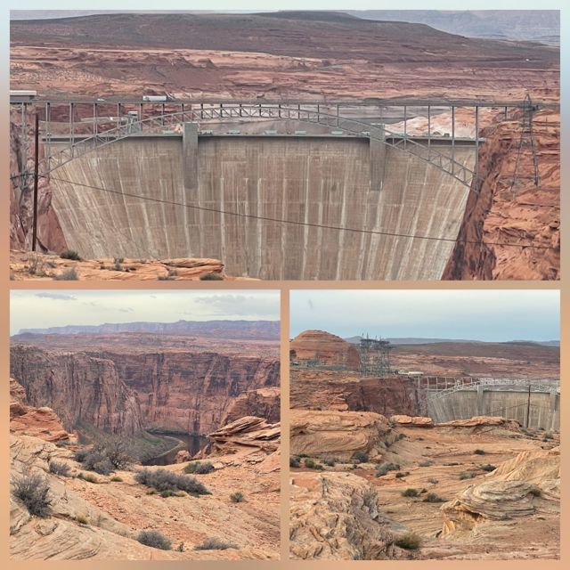
Day 22 – Wednesday – Just outside our motel in Page, AZ was a viewing point of the Glen Canyon Dam. So, our first stop was close and quick. Today was the first day in many, many days that started out cloudy with a forecast of clouds all day. It reminded us of home but not in a good way.
Our drive to Mesa Verde National Park (45!) didn’t have a lot of stops but the scenery continues to be awe-inspiring. It’s amazing how much the terrain can change in just an hour or even less. Today’s drive was about 4 hours, and we saw brownish sagebrush, sandstone almost everywhere, rich red buttes near some mostly black buttes, red “baby rocks” and drove through juniper forests.
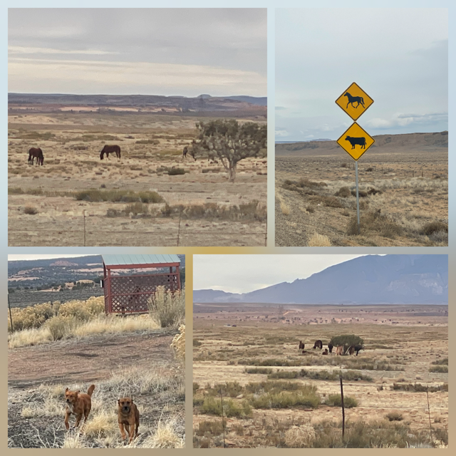
We saw what we think were wild horses. The strangest animals we saw were 3 dogs (twice!) the first set were waiting at what appeared to be a train stop. Let me explain: There was a railroad track running parallel to our road for miles, about 20 yards off our road. At one point, we noticed that every so often there would be a little shade structure that we both thought reminded us the train scene in "Fiddler on the Roof". As we drove by one, I noticed 3 dogs? coyotes? hanging out around the table under the shelter. I did a U-turn to go back and investigate. When we started to pull in, 2 of the 3 dogs (definitely dogs) came running toward our car. We weren't sure of their intentions so I just pulled away. As we did another U-turn and drove by them again, they were back at the train tracks, apparently waiting for a train? Now that isn't the only strange part. 5 or 10 miles down the road, what do we see? 3 dogs running together, free, along the same railroad tracks. We don't have any explanations to offer. :-)
Just 1 mile off our route today was Four Corners Monument. It’s official, Chris and I can both say that we stood in New Mexico, Arizona, Utah and Colorado all at the same time.

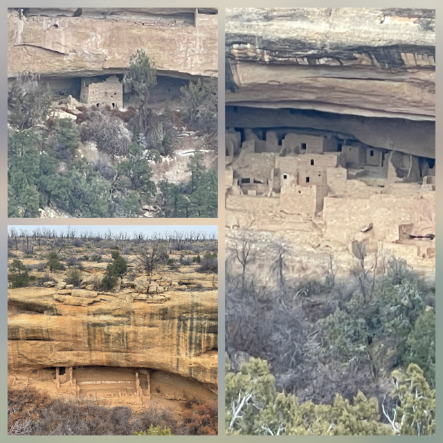
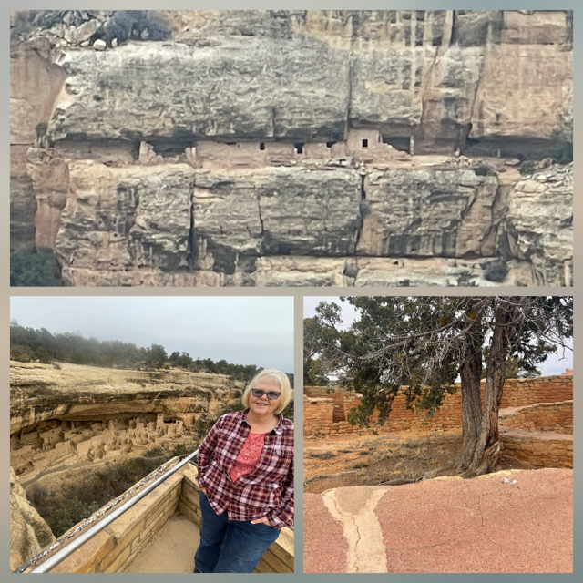
We arrived at Mesa Verde without knowing for sure what parts of the park would be open. My expectations were rather low, but I could not have been more wrong. Even though Mesa Verde reaches heights of 8,500+ feet, it had very little snow, so the roads were great. It still had closed sections, but we were able to see much more than I anticipated. The scenic drive goes along the edge of the cliffs, providing many viewing points of the cliff dwellings on the other side, less than ½ mile across. If the views weren’t enough, we also had a nice herd of deer cross right in front of us in the park as the sun was setting and then we saw another pair in a meadow near the park's exit. It was a great afternoon.
Tonight, we are staying at the “Retro Inn”. It has black/white checked floors, the breakfast area looks similar to a malt shop and, of course, it has both an Elvis bust in the lobby as well as a room dedicated to him. No, we did not get the Elvis room.
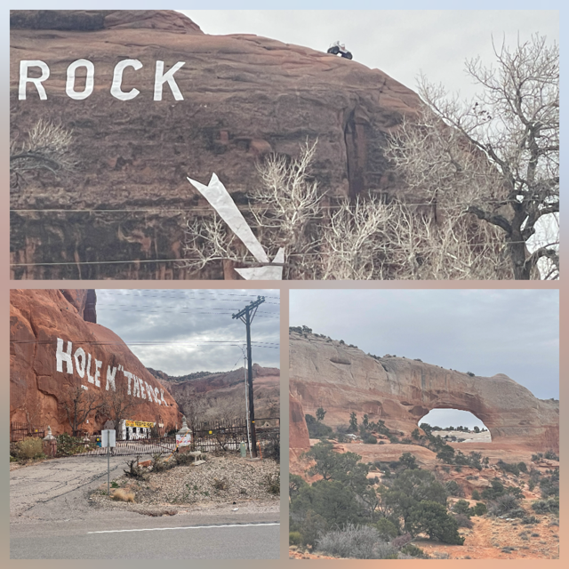
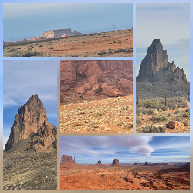
Day 21 – Tuesday – Today was a mostly driving day (5 hr.) but that doesn’t mean we weren’t seeing things because today’s drive went through the heart of Monument Valley! But before we entered Monument valley, we saw the famous “Hole in the Rock” tourist trap (with a jeep on top of the rock). A man decided to build his house by carving it out of a giant sandstone rock. Near by was Wilson Arch.
We went through Monticello UT which had the first Deer Migration crossing signs and they were not kidding. We saw so many deer, including many in the town and on people’s front lawns. It was as if we were in Michigan. The deer are big, like Michigan deer. Outside of town we saw even more deer, migration tunnels under the road for the deer and the highest fences we seen since Newfoundland’s Moose fences.
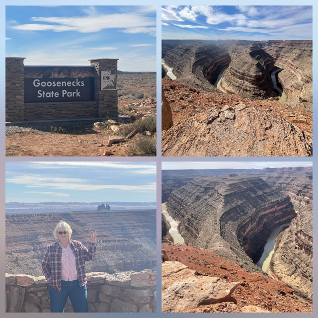
Further down the road we visited Goosenecks State Park UT to view “one of the most striking examples of an entrenched river meander on the North American continent”. Twenty years ago, we saw Horseshoe Bend and this one was just as beautiful. In addition, we saw a turkey and another hawk sailing just above the brush and then landing (though we couldn’t tell if it had caught anything.)
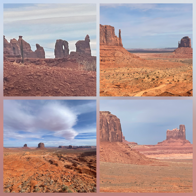
Finally, we entered the Monument Valley portion of the drive. Wow! As we drove I kept replaying in my head so many westerns I watched growing up with these ancient giants in the background.
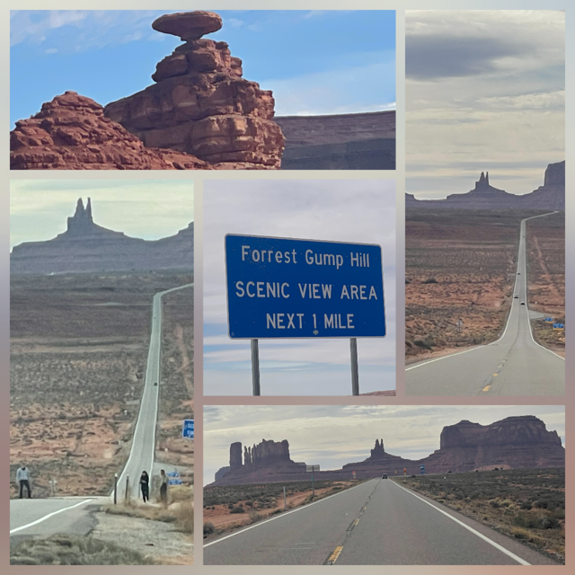
Right after we stopped to view "Mexican Hat" rock, we did what maybe was the #1 thing of the day, having lunch at the Forrest Gump point. Remember in the movie when he stops running out in the middle of nowhere. Well, nowhere was Monument Valley and that point has become a tourist spot. The speed limit is 65 down that road but as you approach the “spot”, they drop the limit to 45. Though we were doing the same thing, it was fun to watch people, families, a dad & son, etc. come and get a picture from the middle of the road. Luckily, you can see miles in both directions so it’s not like cars can sneak up on the tourists!
Also on the drive, we visited the Navajo Tribal Park where you can get up closer to some of the famous rock formations like the East and West Mittens, Merrick Butte and others. They also have a very nice museum focused on the WWII Navajo Code Talkers.
The drive finished in Page AZ, next to the Glen Canyon Dam and Lake Powell.
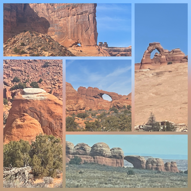
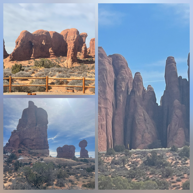
Day 20 – Monday – We stayed in Moab today in order to have a more laid-back type of day. We started the day going to Arches National Park. The last time we were here was 20 years ago this coming summer on a family vacation. Arches is a unique place. We remembered certain arches and sites when we were with the boys but the #1 site with memory was when we saw “it” was still there. “It” had not fallen or somehow been damaged. We texted the boys as soon as we could to tell them we saw “it” as they were the ones who named "it", “it”? Why Homer’s (Simpsons) Butt!! 😊
We spent the morning in Arches, where we saw over 10 arches, a bald eagle and had clear skies yet again. Unfortunately, expectations were for clouds to move in later today.
After Arches we came back to Moab and had lunch while we were at a laundromat. As we were heading back to Canyonlands after laundry, we stopped at the famous Lin Ottinger's Moab Rock Shop. An amazing number of rocks and range of fossils that went on forever.

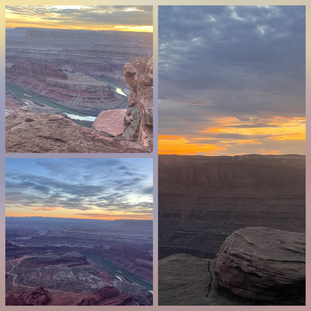
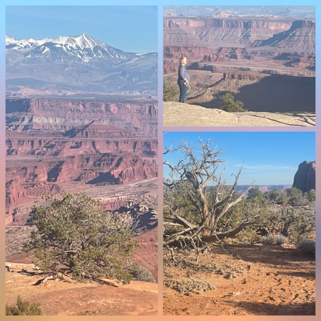
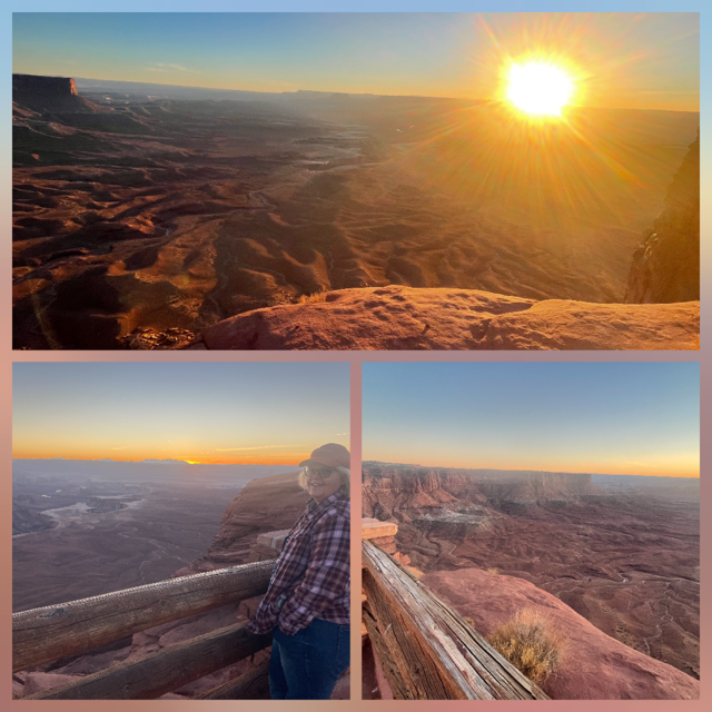
We hoped to watch another sunset over the Canyonlands. Per my research, the best viewing spot (after the one we did last night) was in Dead Horse Point State Park. After the rock shop, I had a couple of viewing points in Canyonlands NP that I wanted to visit and, ideally, end the day at Dead Horse Point for whatever sunset we would find. We visited Shafer Trail, Buck Canyon and Candlestick Overlooks. In addition to all the great scenery in Canyonlands we reached 5,000 miles on our trip odometer.
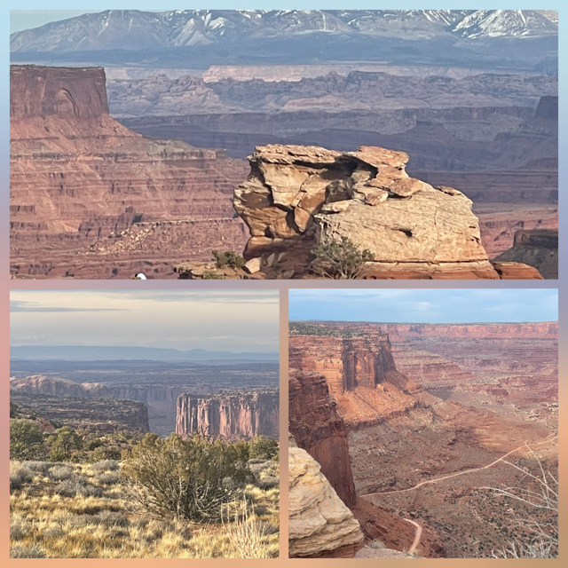
We then headed to Dead Horse Point, watching clouds coming in thicker all afternoon, hoping it would be worth the drive to see the sunset. While the sunset itself was somewhat cloudy, the panorama view of the Colorado River was awesome.
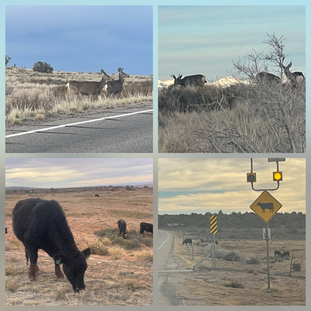
We have been seeing Open Range Cow Crossing signs for most of this trip and have never seen any cows near those signs. We have seen lots of cows, but never in the “open range”. Well, on the drive into Canyonlands today, not only did we see free range cows along the side of the road, but they were also right next to a warning sign! The cows didn’t seem to mind us taking their pictures. In addition to cows, we also saw a Buck and 5 Does, a Jack Rabbit and a hawk landing on the butte right next to our car.
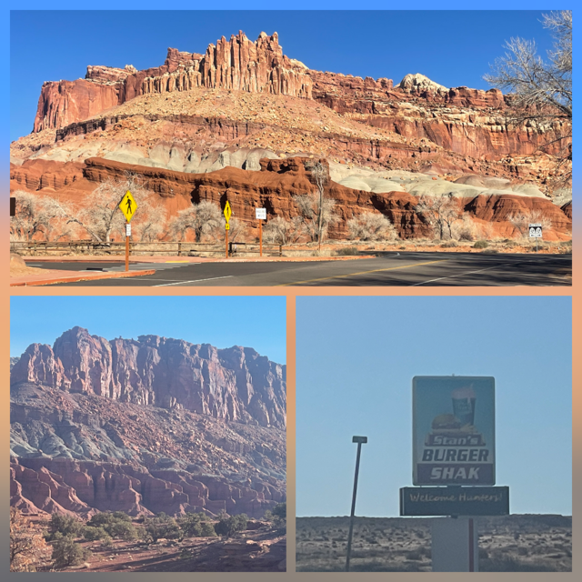
Day 19 – Sunday – Before we left Capitol Reef this morning, we made one more stop: Panorama Point. Of course, the view was incredible. Our next stop was Hanksville UT as Nick had told us of a hamburger joint he and Rayla had found on one of their vacations. It was early for lunch but what the heck. They were right, it was excellent.
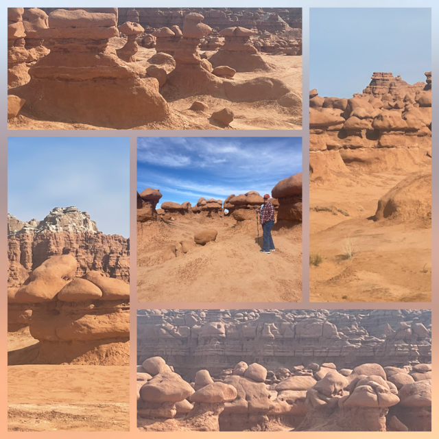
Next up was Goblin Valley State Park. This was another suggestion from Nick & Rayla. A valley full of hoodoos. We hiked into the valley to see them up close and you can see where people could spend the day wandering among them. They take so many images when you look at them and yet, take a few steps in a different direction and they look like something completely else.
Capitol Reef and Goblin Valley are located on state highway 24 and I had read that the road itself was incredibly scenic. Having driven it all, I can swear by that. Even if you had to drive by the NP and the Hoodoos, the views from the road were amazing. It is 163 miles long and the different number of rock formations, colors, views, just never ended.
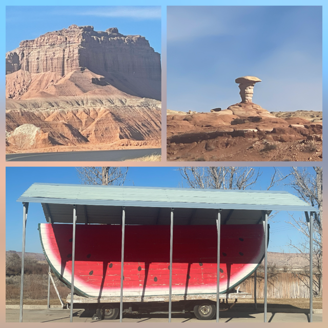
We made a quick stop for gas in Green River on the way to Canyonlands. Green River considers itself the watermelon capital, I leaned this as I researched for our trip. So, of course they have a giant watermelon slice. The fun part is it is the SECOND Largest Watermelon Slice in the World! Not the Largest, the 2nd largest. Love that!
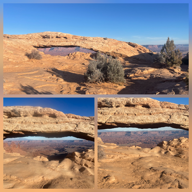
We arrived at Canyonlands visitor center just before it closed. Luckily, we had enough time to ask the ranger for suggestions for the rest of our day and tomorrow. He recommended a hike to Mesa Arch and then to go to one of the two most popular viewpoints for sunsets, which sounded good to us. The hike was relatively short, up and over a hill to the arch but the trail was somewhat hard to follow. With the intense sun, Chris wasn’t feeling quite right so when we got to a point where she could see the arch, I suggested she stay there and I would finish it to get some closer shots. As you get close to the arch, the trail more or less disappears as people walk all over the place. This only became important when I turned around to climb back up to Chris. First, I took some pictures and waved to Chris and then I headed back. After walking for a little while, I started wondering why I had not found Chris yet. In the meantime, Chris could only see me at the arch so she knew I had headed back but could not track me visually. Well, you guessed it, I was walking back on a 2nd trail. I stopped, back tracked a little and then I used Chris’s superpower. Chris can hear like no one else I know. So, I said her name (not yelled, just said it) and sure enough, she immediately responded. After a few ‘Marco-polos’, we spotted each other, had a good laugh and headed to our sunset.
We chose the Green River Overlook for our sunset location. The ranger said the 2nd best spots are like 1A and 1B, can’t go wrong with either. The sunset was as you would want it to be. Massive valley below you with the Green River cutting out a canyon and the sun setting over a mountain range. Tomorrow we may try the other sunset location. We made it to our hotel near the start of the 4th quarter of the Super Bowl. From what I saw, Canyonlands was by far the better viewing this afternoon.
Note: We finished our 4th book - The Correspondent: A Novel
Day 18 – Saturday – First, we visited our general store for a couple of gifts
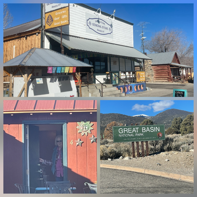
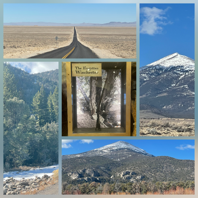
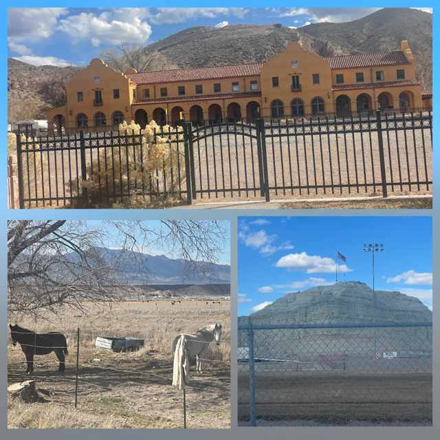
and then headed to the Great Basin National Park (#43!) Visitor Center. It had a lot of great information including animals in the basin so now we know that yesterday we saw an Antelope Ground Squirrel. An interesting story was "The Forgotten Winchester". In 2014 archeologists found an 1873 model Winchester rifle leaning up against a Juniper tree in a remote section of the park. Based on the weathering, x-rays and such, they estimate it could have been leaning against the tree for 100 years or more. Our ability to enjoy the park was limited because the scenic drive to the top Wheeler Peak was close because of snow (we knew it would be) and the Lehman Caves were also closed for renovations (we learned this back in early January). Even so, we were able to drive past the 7,500-foot elevation where the snow started. Also, there is the Baker Archelogy Site which is a village from about 700 years ago. They discovered it in 1991 and dug/researched it till 1994 and then they reburied it to protect it. We didn’t know they sometimes bury the site to protect it and allow them to excavate it again at a later date if needed.
Earlier in the blog I pointed out that there were 4 desert environments in the US and we had already visited three. Great Basin is the fourth and know as a “cold” desert – which we can attest to! 😊
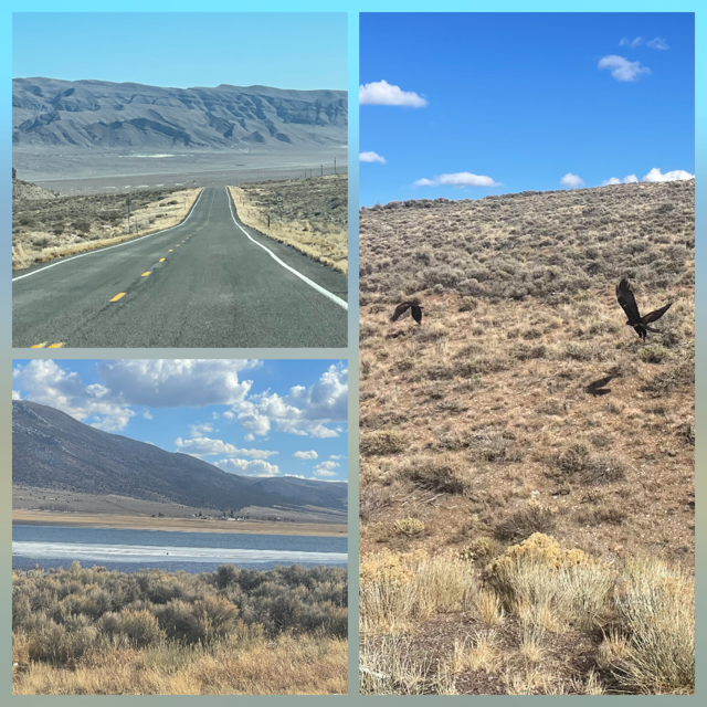
We left Baker and turned on US 50 again. This is east / west road across the country, and it has its own nick name. It was famously dubbed the “Loneliest Road in America” by Life magazine in 1986 due to its desolate, central Nevada stretch. It’s very easy to see why. We drove miles and miles of straight highway and only saw a few cars and because it is so flat, you can see those cars 10 miles away. Of course, it eventually runs back into mountain ranges and farming valleys and such, so scenic.
Funny story: As we drove into Utah, the next town we would drive through was Delta UT. I told Chris that if my memory was good, we had dug fossils (trilobites) with the boys 20 years ago this coming summer. We were about 60 miles from Delta and off in the distance was the first billboard we had seen in probably 100 miles – and it was only about 1/3 the size of a “normal” billboard. As we approached it, we could read “U-Dig Fossils”, and it had a big arrow down a dirt road and said “20 miles”. THAT WAS THE PLACE. I was shocked that we had just “found” it and found out we had driven the next 50 miles to Delta before. No, we did not go do a dig, they were closed for the season.
Along the drive we saw our first buffalo! Okay, they were on a farm, but when you are out west, driving down a canyon and see buffalo, it is still cool. But what we saw next was WAY MORE COOL. We are always looking for animals or birds as we drive and today, out of the corner of my eye, driver side, down off the shoulder of the road was, what I thought to be, a Golden Eagle just sitting there. Luckily, we were on a road where cars are about 5 miles apart, so I pulled a U-turn and told Chris to roll down her window and get the camera ready. As we approached the area we couldn’t see anything and then 2 Magpies suddenly took off from the brush followed by not one but TWO Golden Eagles!!! AND Chris got 2 pictures of them flying.

We entered Capitol Reef National Park (#44!) This park really surprised me. It was much more incredible than I expected. We stopped at the Visitor Center, and we approached a Ranger to try and confirm our Golden Eagle sighting. The Ranger was very excited that we had seen two and asked to see our pictures. We showed them and then she asked if we would share them with her. She then shared with us she saw one in January sitting and she took a picture; she shared it with us. We drove the scenic drive down and back (not a loop) but since it was after 4:00, the sun was getting low so we had excellent lighting and on the drive back, it was like a entirely different drive. As we approached the exit to the park, we came across a herd of deer (1 big buck, 8 does).
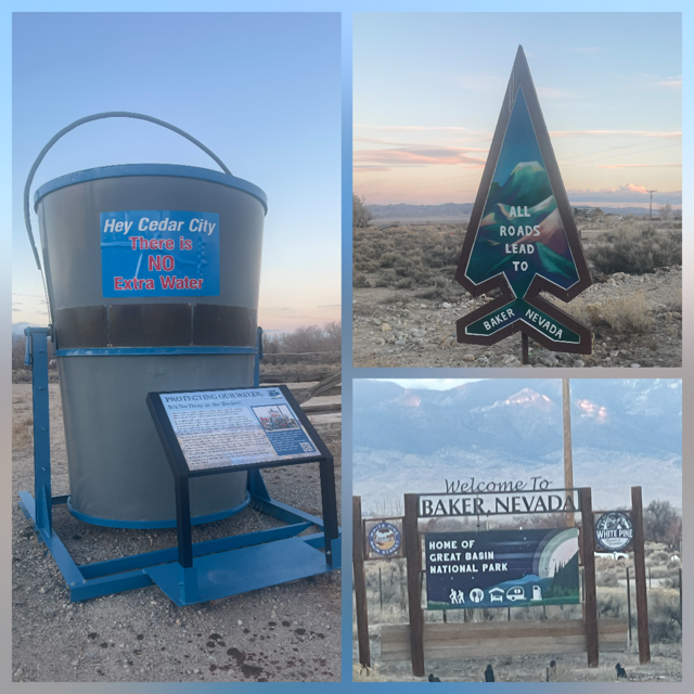
Day 17 – Friday –With everything we did yesterday and the fact that we moved up our visit to Valley of Fire a day, meant we had more free time today. So, what did we do? We slept in! 😊 We didn’t get up until almost 9:00. Woot Woot. We left the Casino about 10:30 and headed to Baker NV (4+ hours). Never head of Baker? Don’t feel bad, on the web its population is listed at 16! More on that later.
Leaving Las Vegas we drove by some massive solar farms. From what I found out on the web some are nearly 10 square miles. The majority of today's drive was on US 93, due north, nearly zero curves in a valley, much like our yesterday's but about twice as far. The uniqueness of today's drive was we had large puffy white clouds so we were constantly driving into large shaded areas and then back in to the sun. The desert looks very different in the shade and you could feel the temperature change.
As we drove north, we came across the Pahranagat National Wildlife Refuge. This was new to us, so we stopped at the visitor center to learn all about how critical this natural spring area is to the California migratory flyway. It was just before many of the migrations started so we didn’t see many birds but to see these wetland “oases” in a desert valley was very unique.
Next was a small town of Panaca, NV. Why, may you ask? Because we are staying in Baker and the 2 food places are only open during the high season, heck there isn’t even a gas station. Panaca had a nice little grocery store so we could get staples for our dinner. They had hot, what appeared to be, chicken fingers and french-fries so we bought one of those for lunch to split. Good thing we only bought 1 as it was 2 chicken breasts disguised as tenders. 😊 We ate our lunch near their high school football field which had a unique location as there was a huge “rock?” formation directly behind it. Also, on the edge of town there were 2 mules that we thought were quite cute.
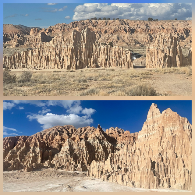
Just down the road was Cathedral Gorge State Park. I had seen this on the web and thought it would be worth the time. It was! Similar, in a way, to Bryce Canyon but you are at the bottom instead of looking from the top and these formations were sand color where Bryce are more red.
We have seen many animal crossing signs on this trip: deer, cattle, tortoise, burrow, elk, antelope, bear and mountain goats. Today, most were deer and cattle until we came across an elk sign and at that point, I made a sarcastic comment about “sure there are elk” given our sightings so far. Just a few miles down the road we saw a big elk. Sadly, it was dead next to the road. That brought us both down a bit but luckily, we then saw our first pair of antelopes and then a small herd of antelopes (about 10) and even 4 wild horses.
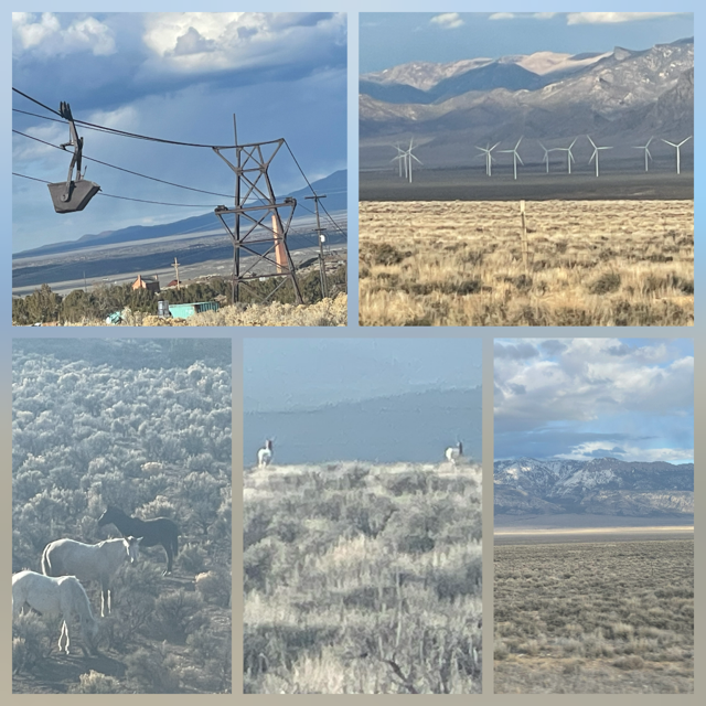
Finally, as we reached the northern end of our drive, we could see a large wind farm at the base of snow-capped Wheeler Peak (13,065 feet) We arrived at Baker and our General Store/Motel just before sunset. The town is so small that when we tried to look up the motel's address, one wasn’t listed on the reservation. 😊
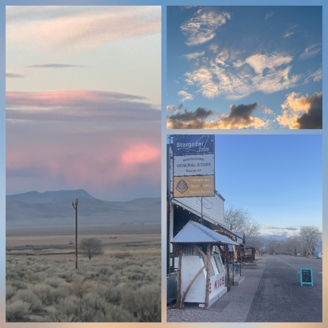
The best thing Baker brings to the table is it is at the entrance of Great Basin National Park AND it is one of the darkest sky areas in the US. We learned from Beatty to avoid the moon so we went out “early” around 7:00, 2 hours before the moon would rise. WOW is the best description; the stars were so bright and plentiful. The longer you looked more seemed to pop out. And the Milky Way was magnificent. We have seen it before, often from near Torch Lake, but tonight’s view doesn’t even compare. It is times like this that I wish I had a better camera. As an extra bonus for the day, as we were driving out into the park to get away from any light, we saw a Black-tailed Jack Rabbit. I can’t be completely sure it was a black-tail but the ears on it were enormous so it was definitely a jack rabbit.
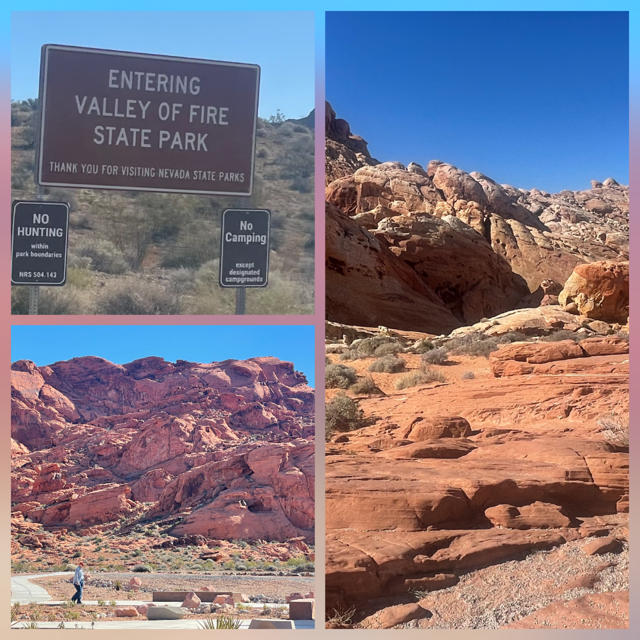
Day 16 – Thursday – We left Beatty and, once again, changed our plans a little bit. 😊 We drove straight to Valley of Fire State Park instead of visiting the park tomorrow. On the drive, we had a weird experience. We came over a hill to a routine view of the road rolling out in front of us for probably 3 miles across a very small “valley”. But this time on the left lane we could see a lot of police cars. We put on our flashers and continued toward them as they were miles away. However. 1 police car started down valley at us weaving slowly across both lanes. At this point I just pulled over on the shoulder and left my flashers on. The state trooper drove by followed by 3 additional police cars. Behind those were two semis that were hauling the “dump box” (the part that they haul dirt in) from one of those HUGE dump truck. The box was nearly 2 lanes wide!
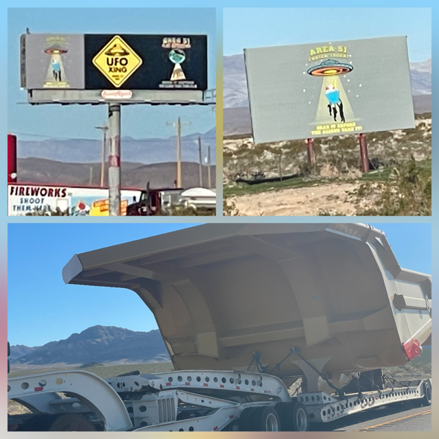
On the drive we finished our 3rd book, “The long way to a small angry planet”. It was a futuristic science fiction, very different from our usual genre, but we enjoyed it a lot. And it kind of fit the theme of today’s adventures. We drove “near” Area 51. How close? Who knows. There is about 100 miles of land to the east of our road that is “empty” and, somewhere in that area, is THE Area 51.
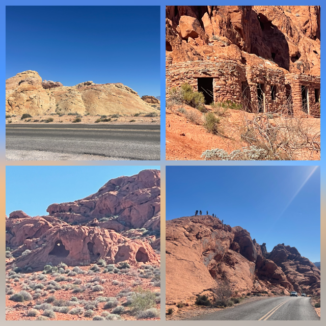
We entered Nevada ‘s first state park, Valley of Fire, through the west entrance. This park came highly recommended by Nick and Rayla and they do know their parks. It was amazing. It’s hard to think that after all the rock formations deserts and valleys we have seen, there was yet another new incredible site that was unique. Wow. The reds of the rocks can’t be done justice by our photos We went out to the Rainbow Vista and the White Domes. We exited the park on the east side so we could see the cabins built by the CCC (1934) and elephant rock.
As we drove into Las Vegas, we went over the 4,000-mile mark.
Our #1 place to visit in Las Vegas was Meow Wolf Omega Mart exhibit. Why and What? WHY is because Nate, Andrea, Nick, Rayla and Chris have gone to a Meow Wolf exhibit and I haven’t. That is just so wrong. 😊 WHAT it is – Omega Mart is a massive 52,000- to 58,000-square-foot immersive art experience featuring a surreal supermarket that serves as a portal to other dimensions, boasting 60 unique environments, 250 art projects, and hundreds of contributing artists. What it is, is WEIRD!!!
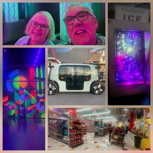
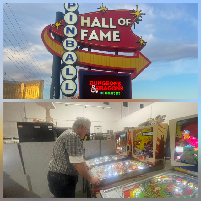
As we left Meow Wolf, it wasn’t quite dark so we wanted to kill some time so we could drive down the strip at night (something we never have done), and go see the Sphere and then, finally, check into The Strat Casino/Hotel. What to do for an hour or so in Vegas? The Hall of Fame of Pinball of course! A pinball machine museum with 1000 machines. It was GREAT. Chris found my favorite game, Eldorado, from the 70’s and I stood there and played about 20 games. VERY PROUD that I STILL can beat it!
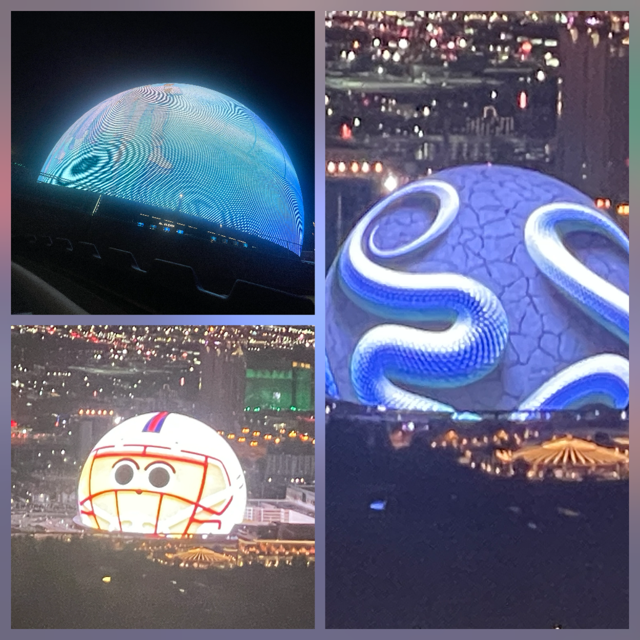
The Sphere was as incredible as we hoped and had heard. They were having a performance of the Wizard of Oz so I just followed the Uber drivers as they went through their drop off lanes, so we were able to drive around about 75% of it and get right up next to it. One of my better ideas. Finally, we arrived at the Strat where I got a very good package price on a weeknight and off season. As part of the package, it included tickets to the top of the Strat (twice the height of the Seattle Space Needle). Great view and yet another great way to see the Sphere.
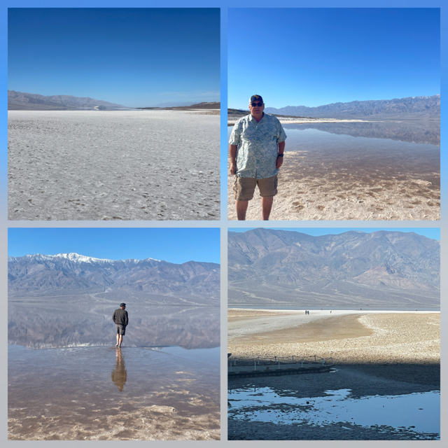
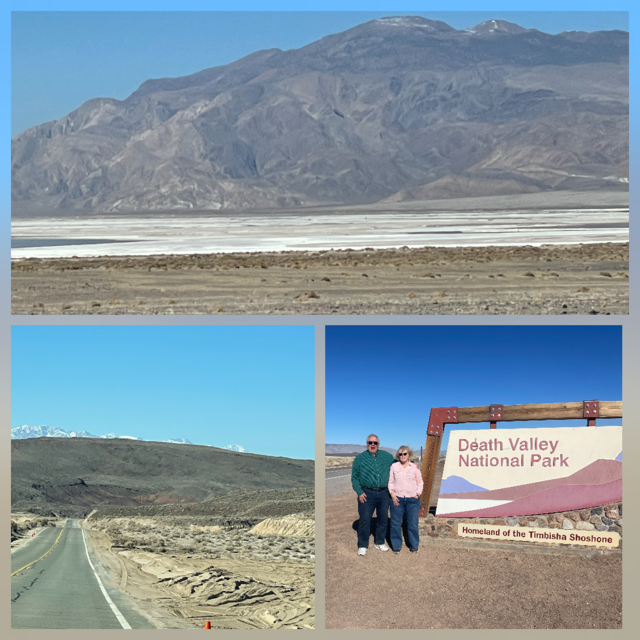
Day 15 – Wednesday – Death Valley all day! With us staying in the Atomic Inn one more night, today was all about seeing as much of Death Valley as we could. Yesterday, we picked up the NPS “newspaper” on the Death Valley and it has the 9 “must see” locations. We reviewed it and realized we had already stopped at 2 and after laying out a route plan, we thought we could see 5 more today. As it turned out, we saw all 5, plus 2 other stops not listed AND found time to go to the “Ice Cream Parlor at the Oasis of Death Valley” and get a phenomenal Sundae! 😊
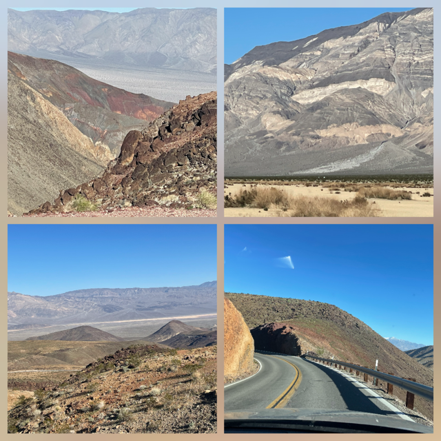
First stop was Badwater Basin, lowest spot in North America (-282 feet) and, because of flooding back in early January, there was a very large lake. Generally, a lake only appears once a decade. In one picture, if you look closely, you will see a white sign on the side of the hill which shows “sea level”. We walked out to where the water started, about 1 mile, and then watched a person take off his boots and socks and walk into the water. It was amazing to look at and even more, when you realize the average depth WHEN there is water is only 1 foot!
2nd - Artists Palette and drive. Hard to appreciate so many colors generated just from the minerals.

3rd - Not on the NPS list but was an incredible drive, 20 Mule Team Canyon
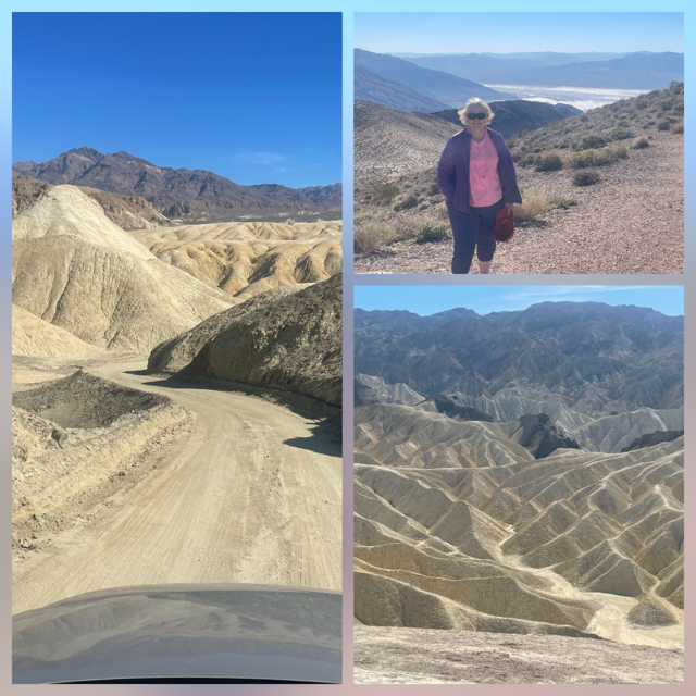
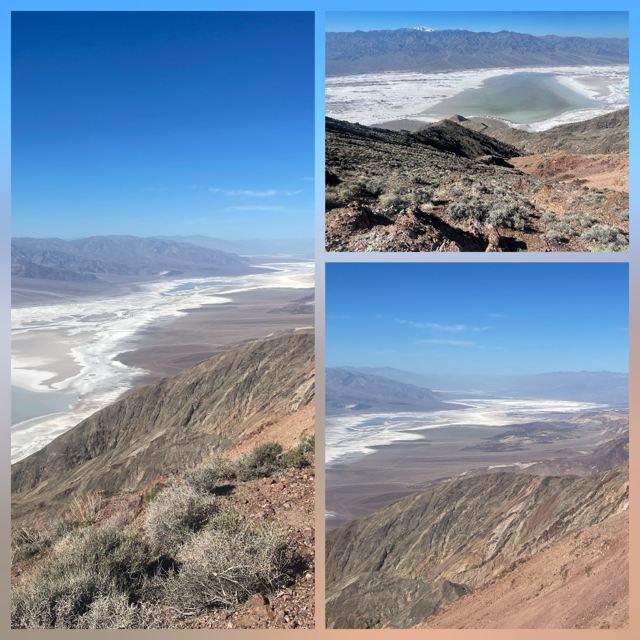
4th - Dante’s View – a 15-mile drive to 5,500 feet and then an incredible view of Badwater Basin
5th - Zabriskie Point, a rather short hike to a viewing point over the “badlands of Death Valley”.
6th - Harmony Borax Works which shows some of the old equipment.
7th – Not on the NPS list but Mustard Canyon, a short drive that we just happened to find an entrance near a parking lot as we were leaving the Borax Works and decided, “Hey, lets go THAT way”. It was a good decision.
On top of this great day, we even found time to do our laundry! Below are some pictures of our Atomic Inn that I mentioned yesterday. Enjoy!
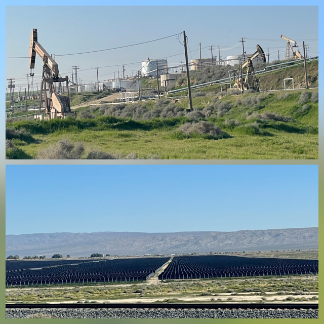
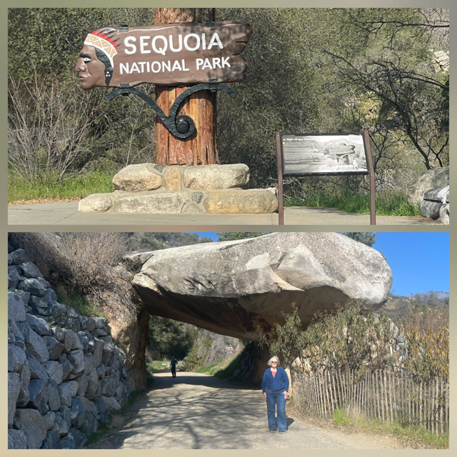
Day 14 – Tuesday – Today was going to be a longer drive day, from Sequoia NP to Death Valley NP. The first 1.5 hours were on the same route that we drove into Sequoia, but it gave us a chance to realize we didn’t share two things: 1) There was a section of oil wells for almost as far as a person could see which was sad, ugly and smelly. 2) There were a couple of very large solar farms which were nice, not ugly nor beautiful but didn’t smell at all.
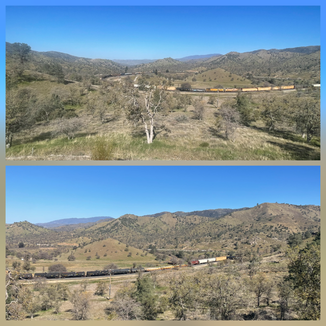
Google provided 2 alternate routes from Bakersfield to the west entrance of Death Valley. I told Chris I wanted to see a civil engineering marvel and she said, “well, let’s go that way!” It didn’t disappoint in any way. In fact, even the road to the viewing point was worth the detour as it was a crazy curvy mountain road. The engineering marvel is the Tehachapi Loop! It is a 128-year-old, 3,779-foot-long (0.72 miles) that allows trains to rise 77 feet by looping over themselves. Trains go through a tunnel and then do a long 360 climb which allows them to cross over themselves. The odds were not in our favor but we got lucky and saw a train do the loop AND they engineers saw us at the overlook and gave us several long "honks" and even waved. Hopefully the pictures will make the loop clearer.

As we continued the drive, our route took us through Red Rock Canyon State Park. What a great bonus. We pulled over to take pictures of a salt flat and right over our head, two jet fighters screamed by. I read that the area is used for training runs. Overall, the total drive from Bakersfield to the West Entrance was gorgeous.

We entered from the west (our 42nd park!) and drove completely across the park as our motel is in Beatty, NV. We made 3 stops as we drove across.
First, Padre Crowley’s Overlook (Rainbow Canyon) – an incredible vista where Father John Crowley used as a point of contemplation.
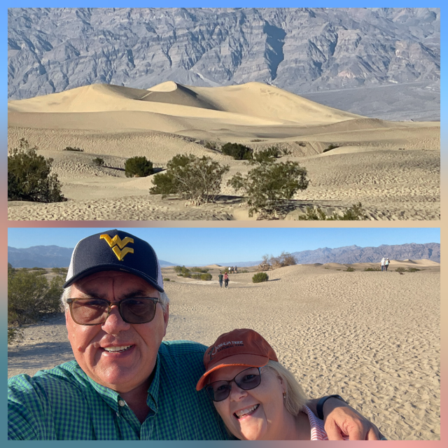
Second, Mesquite Flat Sand Dunes – 14 square miles of olive colored sand dunes.
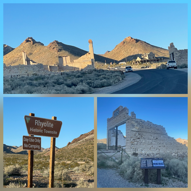
Third, the Rhyolite ghost town – “Gold town” that founded in 1905 and mostly gone by 1910! In that time, it swelled to 5,000 - 8,000 people and had 18 grocery stores, 50 saloons, 4 bakeries, 6 barbers and three railroads! If that wasn’t enough, it is also home to the Tom Kelly Bottle house (made of 50,000 bottles). 😊
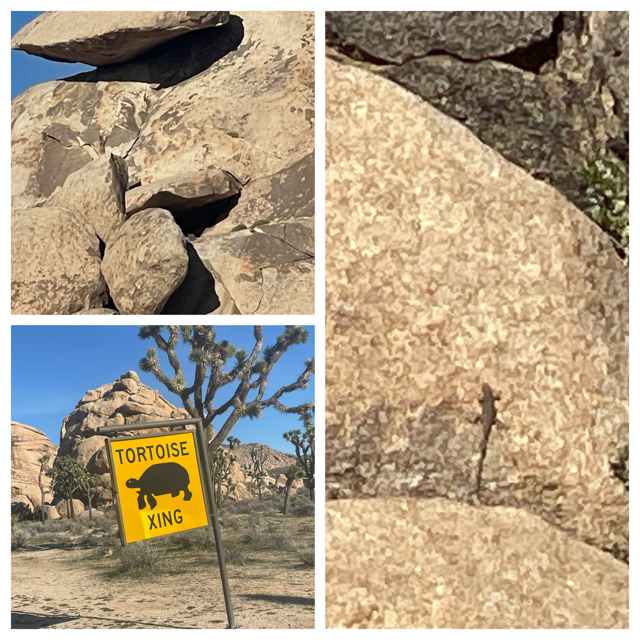
Lastly, as we were nearing the eastern edge, there were signs to watch out for the Desert Tortoise. We didn’t see any but then we noticed that just like Newfoundland had its long and high moose fence along the road, the NPS has what I am sure they are just as proud of, a “Tortoise Wall”. China has nothing on this wall!
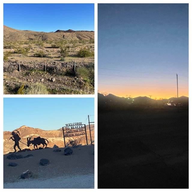
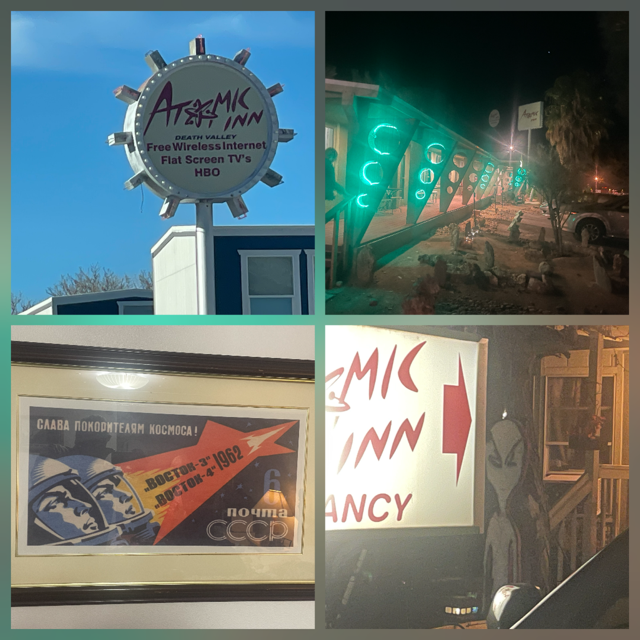
We are staying at the Atomic Inn, a classic motel with the “atomic age” theme that includes one of the pictures on our wall being a remake of a Russian Sputnik poster and fake “bombs” stuck in the ground outside. So cool!
We finished the night by going back into the park near the ghost town and turning off the lights and viewing the night sky. We had a nearly full moon which was amazingly bright so seeing the Milky Way wasn't going to happen but it was still impressive to see so many stars even with the moon's light.
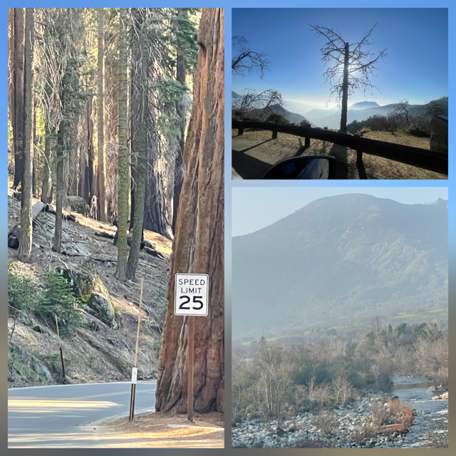
Day 13 – Monday – We woke up and listened to the local LA traffic report. Bad news was it was exactly as you expected. Good news is we were north, in Ventura, so our drive was east from the coast and then northeast to Sequoia National Park and the roads were wide open! Of course, as we came down the mountain pass into the San Joaquin mountain the road signs informed us of a severe fog warning from noon till 1:00pm. The fog was never thick enough to cause any driving issues, but it did make the whole valley look “Michigan grey”. ☹
As we left, we officially started the “heading home” part of the trip. The first part of the trip was 2,980 miles. Looking back at our last trip and this one, about 4+ months ago we were on the island of Newfoundland, city of St. John’s (furthest point east on North America) and yesterday we were on the island of Santa Cruz, west of the California coast. Who would have thought?
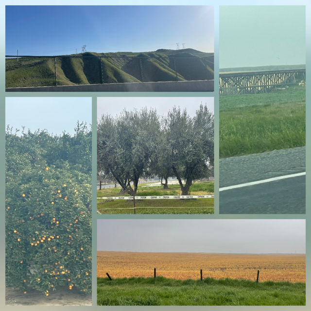
The drive today was made up two major parts: Miles (like a 100?) of orange and lemon tree orchards and crossing the Tehachapi mountains - a steep, 40-mile section that connects the Santa Clarita Valley to the San Joaquin Valley, rising to over 4,100 feet in elevation. The views of 8 lanes of traffic winding through the mountains were intense. I have no idea how many oranges and lemons come out of the two valleys, but it sure seemed like they could supply them all. The only traffic we had was in the middle of an orange grove where the power company was switching out a transformer and had our road down to one lane. It only cost us about 5 minutes of sitting and our reward was at the next stop sign there was a line and while waiting, we identified the third tree we had been seeing: Olive trees!
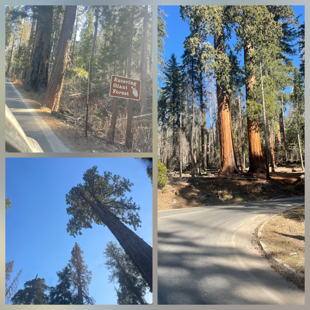
As we arrived at Sequoia we started going to a higher elevation and, “poof” the fog was gone, and we saw 3 wild turkeys. Woo Hoo! The road completely through the park was closed because of winter but it was open to the Giant Forest and General Sherman Tree. We drove up until we eventually crossed the 7,000-foot level, where snow appeared and we decided that it was high enough. We turned around and then stopped at the General Sherman and hiked around its grove. Seeing a Sequoia never lets you down. Their immensity and beauty are amazing.
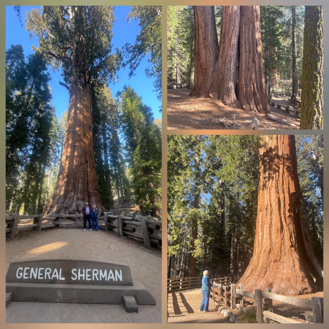
This was the 6th National Park we visited on this trip. Three new ones and three repeats, the beauty of the parks never disappoints.
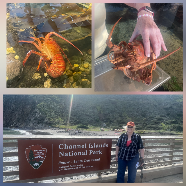
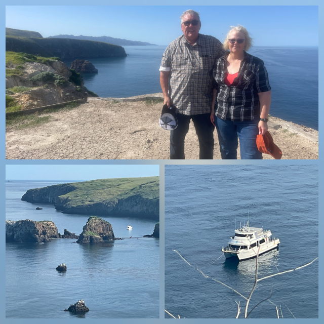
Day 12 – Sunday – We got moving early today, guess we were excited for our boat ride out to the Channel Islands National Park. We arrived before the Visitor Center even opened! 😊
In the Visitor Center they had many nice exhibits, one included life fish and crustaceans. There was a lobster and as we were looking at it, the Ranger explained it had recently molted and then showed us the shell it had shed. We can’t really imagine how that process can even work.
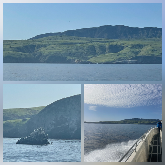
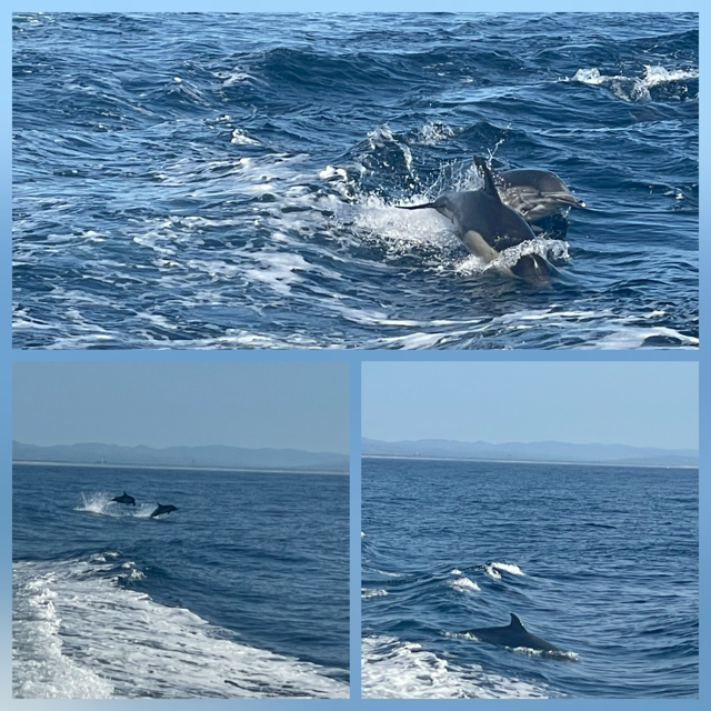
The boat ride was smooth, more or less. There were some swells so every so often you could feel the boat rise up quite a bit and then rush down again. It was fun. We saw the first of what would be 100’s of brown pelicans and then the captain put the boat among a pod of dolphins, and we had them on all sides playing, eating and racing the boat.
Arriving at the island reminded me of arriving in the movie Jurassic Park. Very green with high cliffs around much of it. We entered the island at Scorpion Cove, where they have a nice pier to meet the catamaran motorboat.
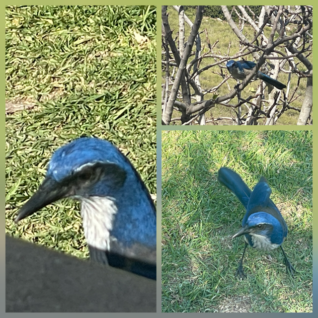
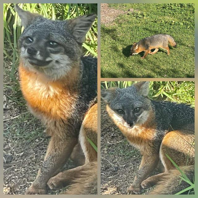
We were on the lookout for the Island Scrub-Jay (only exists on the earth on this one island) and the Channel Island Fox (only exists on the earth on 5 of the 6 Channel Islands. We heard a Scrub-Jay right away and had a momentary glimpse of him. No view of an Island Fox in the areas they told us they are most likely spotted (they are NOT afraid of people as they are at the top of the food chain on the islands, so they often walk around people).
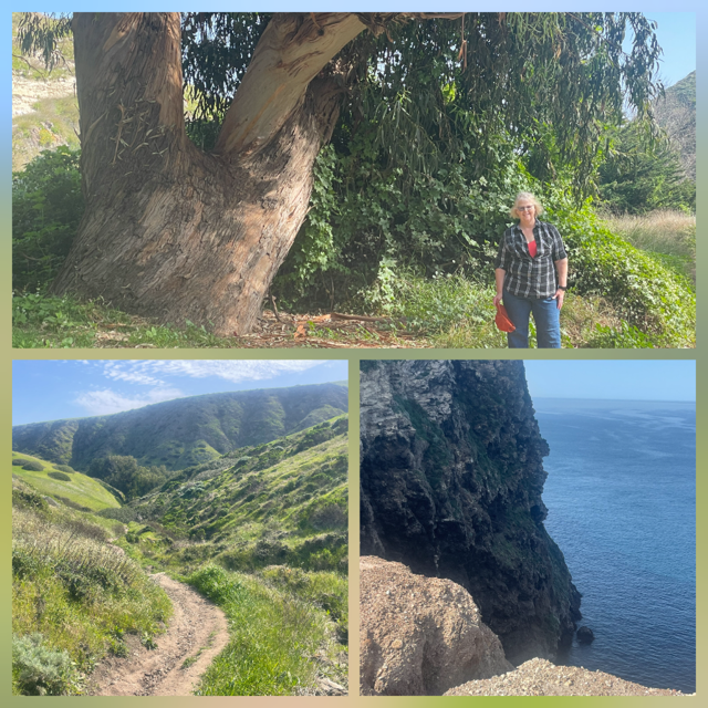
Having finished walking through the 100+ year old ranch house and grounds, we decided to hike the Cavern Point trail. It has an elevation gain of about 350+ feet which means it provides incredible views. The views were incredible, but the hike was more than we expected. But we took our time, had lots of water and we MADE IT! We saw several lizards on the hike near the end but, at that point, I was more interested in not falling off a cliff than taking another lizard picture. 😊
Upon returning to the cove, we were sitting at a picnic table, enjoying some snacks we brought with us and what shows up? A VERY friendly pigeon (sorry, not a Scrub-Jay or Fox). Feeding any animals is strictly forbidden but that didn’t stop this guy from sitting at the table 2 feet away and staring at us. 😊 After we shooed him away, we were still sitting there, resting, when suddenly, a Scub-Jay flew into the bush about 3 feet away from Chris. He spent a lot of time and even jumped on our table. In the “birding-world” seeing a Scub-Jay is a bucket list type activity. Not because they are so hard to find on the island, but because they only exist on this ONE island in the whole world.

Well, we were sitting quite happy now as we had some very good pictures of a Scrub-Jay and what walks up to our table? Yup, an Island Fox!!! It was much smaller than I expected but, again, we were able to get some very nice, close, pictures. Needless to say, we spotted our two most wanted and survived our hike. What a GREAT day. The boat ride home was nice and smooth, and we headed directly back to the room as we had bought dinner last night and it was in the refrigerator, so we were ready to relax.
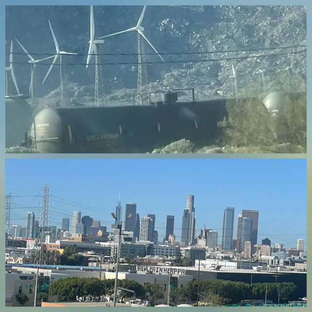
Day 11 – Saturday – While I had some ideas for today, we started the day with plans to take it easy and, if time allowed, see what we could. First up, the Griffith Observatory. We pulled out of Palm Springs at 8:30 with a projected drive time of 2 hours. Three hours later we were still 50 minutes away. How was this? Probably because it took us over an hour to travel 2 miles because of an accident. Reality of driving in LA can be bad, really bad. Looking for the bright side, we had a nice view as we were in a mountain pass, and we were able to watch two different trains go by us extremely slowly as they were still on the upward part of the track. Better than watching them blow by you when you are sitting still, right? Also the mountain pass has many windmills, including some that looked as if they were first generation from 10 years or more ago. They had classic metal pedestals that we haven't seen before.
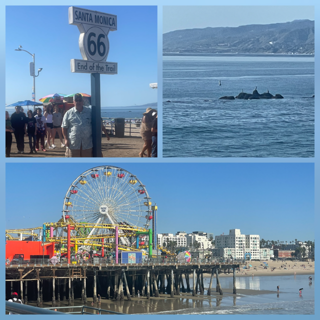
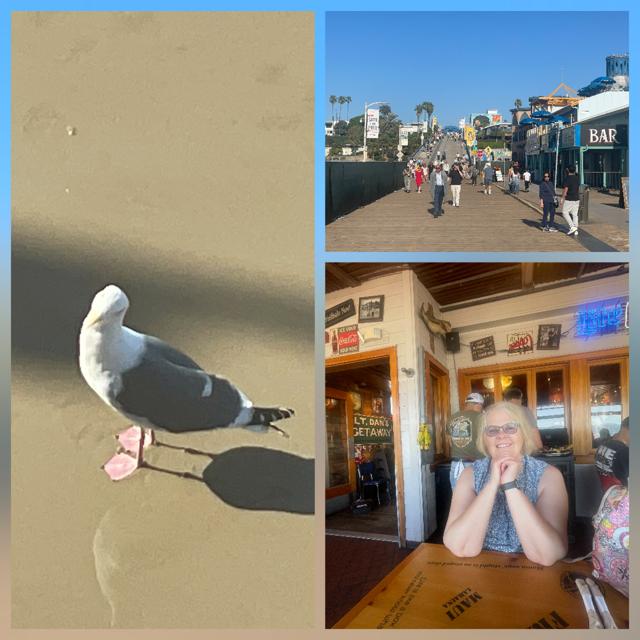
With traffic being what it was, we stopped for a quick lunch and decided the observatory was off our list today. Next up, Trejo’s Coffee and Donuts. Why? Trejo is a famous actor, and his donut shop has appeared in a few different tv shows, including one of our favorites, “Bosch” so we thought it would be fun to see it. Unfortunately, Trejo’s made our list because it was near the Observatory. No Observatory, No Trejo’s! Last up was the Santa Monica Pier.
As we rode to the pier, roads were generally better, so we arrived around 1:00. Getting a picture of the End of Route 66 sign almost immediately. It was low 80’s with a great, cool breeze with perfectly blue skies. While there were crowds, they were not huge, so they were manageable. There were people swimming and playing on the beach. We walked the pier, listened to street performers, caught a lot of rays and enjoyed the beautiful, sunny day. We stayed at the pier for a few hours and went to Bubba Gump’s Restaurant on the Pier for an excellent early dinner.
We left the pier and headed to Ventura. The route was up the Pacific Coast Highway 1 and then through the mountains on the Topanga Canyon Blvd. One part of the day we both enjoyed was spotting roads that we recognized. Topanga, Wilshire, Crenshaw, Mulholand, La Brea, etc. The drive through the Topanga canyon was incredible. Of course, they were doing construction and had it down to one lane so that added a 15-minute delay on a 30-minute drive!
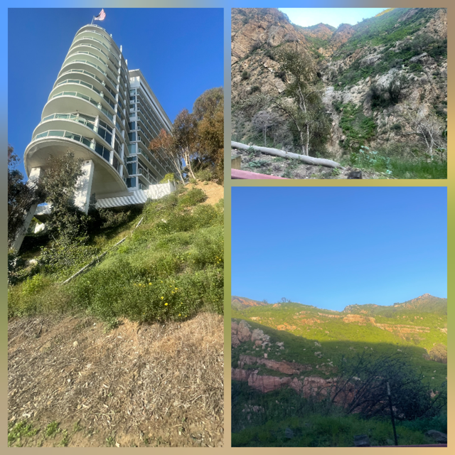
We made it to our motel in Ventura around 6:00 and it is a “classic” motel, our room is very nice with a full kitchen with windows on 3 sides.
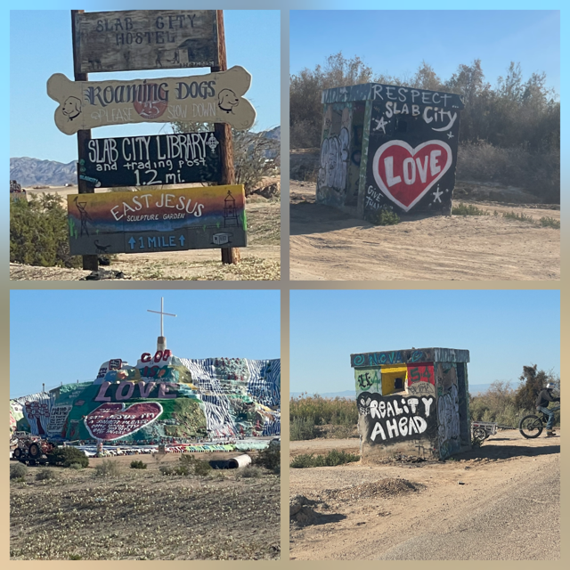
Day 10 – Friday – We are getting used to the time change as we woke up early on our own. We left Brawley and headed to Slab City to see “Salvation Mountain”. Slab City is an unincorporated, off-the-grid alternative lifestyle community consisting largely of snowbirds in the Salton Sea Trough area of the Sonoran Desert. It took its name from concrete slabs that remained after the World War II Marine Corps Camp Dunlap training camp was torn down. It is often described as being quite “different”, it didn’t disappoint.
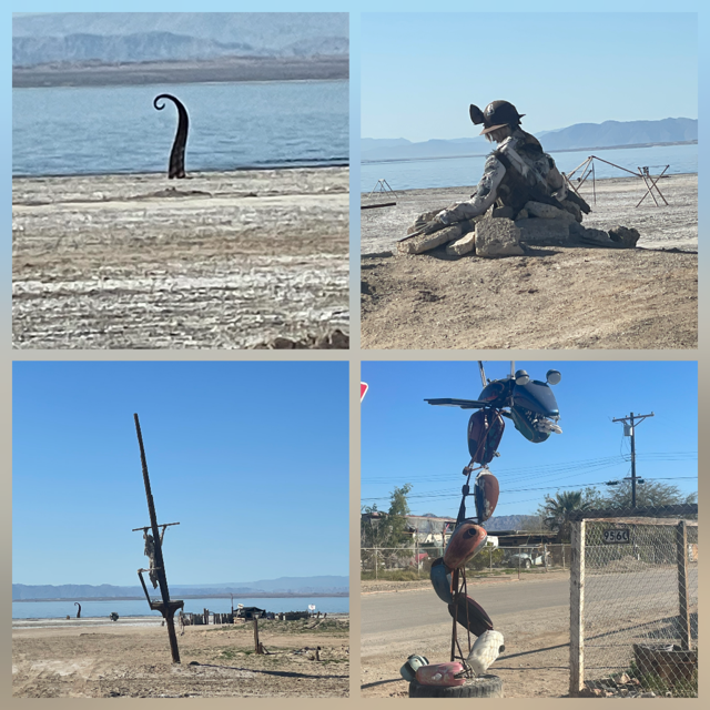
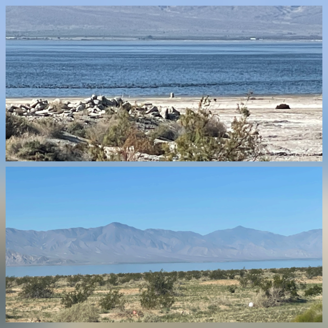
Next, we drove the east side of the Salton Sea. The sea has a long, strange history. At one point, it was believed it would become a huge resort destination. Unfortunately, pollution and other changes have nearly destroyed the lake. Only time will tell if nature rights itself. In the meantime, there are 2 “communities” that have held on as their property is basically worthless. The first is Bombay Beach and the second is the North Shore Yacht Club. When so much is taken from someone, they find ways to cope. In this case, it is with strange and, sometimes, funny, humor via “art”.
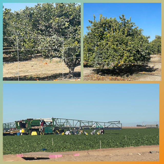
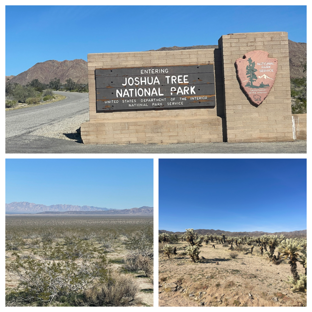
Leaving the Salton, we headed to the south entrance of Joshua Tree National Park, our 2nd new park on this trip, 4th overall. Driving 40 miles was amazing. The first 20 miles were still in the Imperial Valley, orange and lemon groves, grapes, cabbage, etc. We saw several teams of farm workers picking crops which were fascinating to see in person. Then, suddenly we turned into the hills/mountains and drove about 20 miles through what we would say were badlands – VERY much like the ones in South and North Dakota.
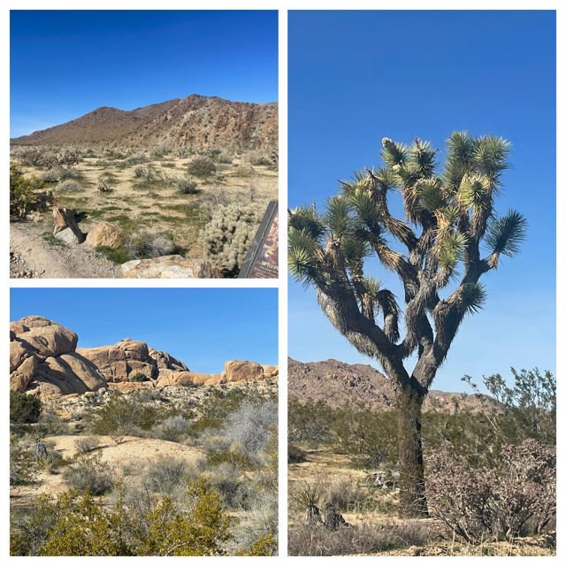
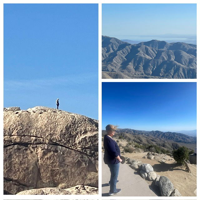
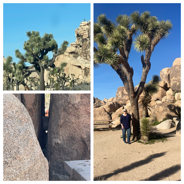
Joshua Tree was incredible. Very much like Saguaro, it has 2 distinct eco systems (but they are all inside one park). The south entrance was still part of the Sonoran Desert so looked like Saguaro – West. We took a nice hike and saw several lizards and with it being 73 degrees with a wonderful breeze, we even found time to just still quietly on a bench on the trail and enjoy the sound of the desert. As we drove across the park, we entered the Mojave and everything changed. The Joshua Trees and giant stacks of boulders start appearing. We drove up to Key View and did a loop hike which gave us a view from just over 5,000 feet over Palm Springs and the Salton Sea. Today’s visibility was well over 50 miles, so the view was incredible. As a bonus, at that altitude, some of the Joshua Tree’s were in bloom.
Finally, we drove into Palm Springs, and I took Chris to see their main street. I had been there about 10 years ago and wanted to see if it was how I remembered. Surprisingly, it was so much how I remembered it was a little bit of a letdown. Lots of restaurants and outdoor seating with lighting and such but it seemed a little dated at this point.
NOTE 1: Yesterday we finished our 2nd book, The Glassmaker. Fascinating book. We were inspired to read it when we visited the Chihuly exhibit in OKC.
NOTE 2: There are 4 deserts in the US. After today, We have traveled through 3 of them. Chihuahuan, Sonoran and Mojave.
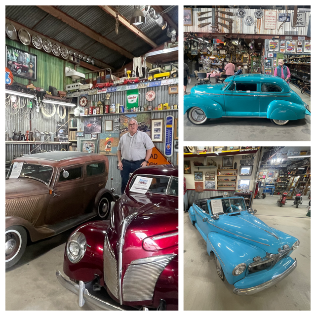
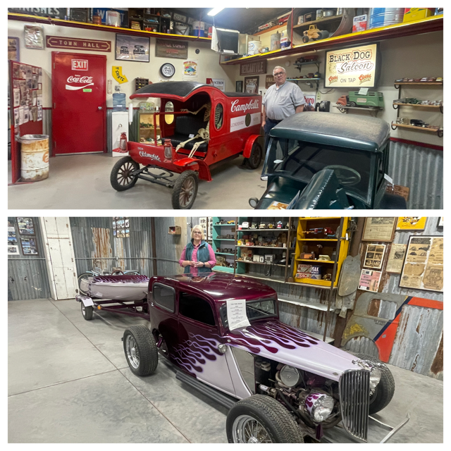
Day 9 – Thursday – We started the day ahead of schedule a bit so instead of staying in Yuma, AZ tonight, we changed our reservation and targeted Brawley, CA. This would be about a 5-hour drive and give us more time tomorrow. With the extra time today, we had to see what we could explore along the way. First stop was the Dwarf Car Museum. OUTSTANDING! The owner started making 5/8 replicas cars that are totally street legal with all working features. He had driven some of the cars as far as Indiana with his first trip to Davenport, IA. He used the motor and drivetrain from Toyota Corollas (1974 – 1982). All of them have steel frames and body panels, and he found ways to create whatever he needed, as he did ALL of his own work. It started out as he wanted to create a new race car (smaller and cheaper) to race and then he started the “dwarf car racing circuit”. His love for the work grew to making classic 5/8ths reproductions. We met him and his son today. Chris asked the son if he ever drives them and he said, not anymore, way too much pressure because everyone on the road wants to drive beside him and take pictures! I almost didn’t go to this museum as it was off the expressway about 10 miles but when Chris read about it, she said YOU must go to this place. As always, she was right!
As we drove through Gila Bend, the Dinos and Space Motel were nicely done. Also, we saw what looked to be cotton along the side of the road for miles and miles. We saw a few cotton fields but could not understand how the cotton could be so far down the road. Then we saw the truck in the picture....
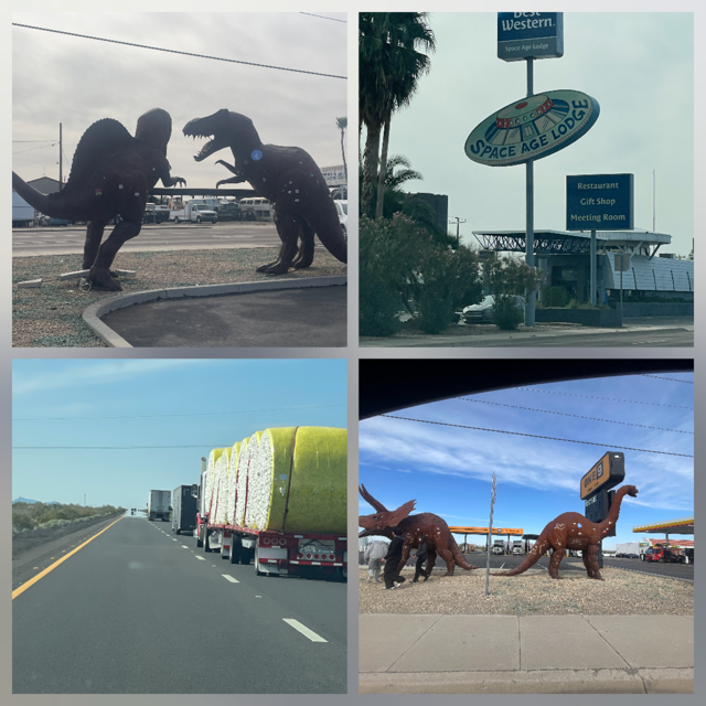
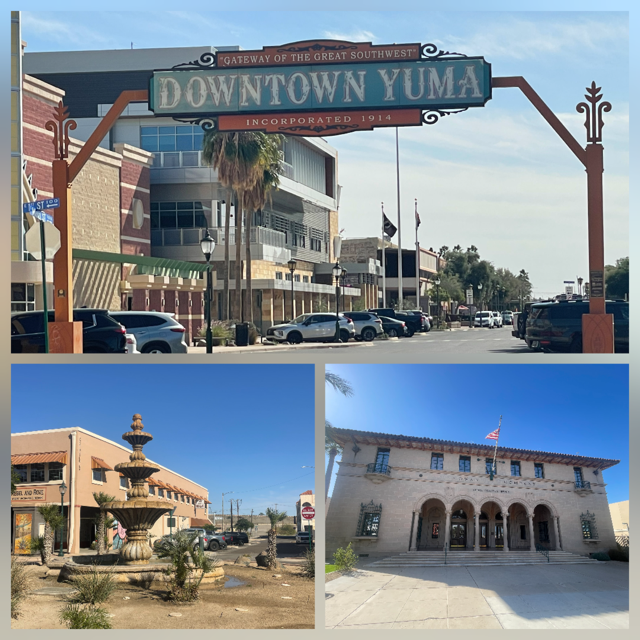
Next up was historic downtown Yuma. We were able to park right on main street and walk up and down. It was a neat town.
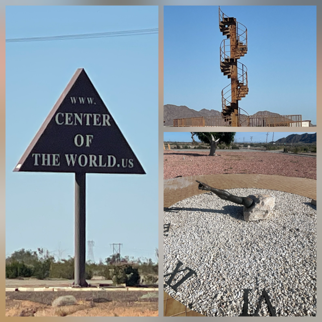
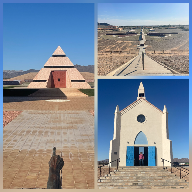
Just outside of Yuma is the “Official Center of the World”. The story behind it is there was a man who realized that no one had claimed the center of the world, so he did and he got France (he is French) to recognize it first, followed by the US and finally, the UN. Thus, after all is hard work, today, Chris and I both stood on the exact “Center of the World” (inside a pyramid no less!) 😊 In addition, he has added the History of the World in Granite (700 granite panels that cover the history of the world), there is a replica of the La Chapelle Notre-Dame d’Espérance – the Our Lady of Hope Church – in Brittany, France, a sundial whose gnomon, Michelangelo’s Arm of God, points to the Church AND a 25 foot section of the ACTUAL spiral steps from the Eiffel Tower. All located in the town of Felicity, CA, which the same man also created and named after his wife and made himself Mayor. Talented and driven guy!
We saw many trains today (all around 2+ miles long) and while at the Center of the World, I was able to count the cars of one train. It had 5 engines in the front, 2 in the middle and 177 total cars.
The rest of the drive, about 2 hours, was into the Imperial Valley. Very flat, tons of agriculture with canals around nearly all the fields for irrigation. Our car has an altimeter built in and while driving through the valley, Chris noticed we were 24 feet below sea level. Later we would see 180 feet below sea level. We knew Death Valley was below sea level but had no idea that other parts of CA were as well.
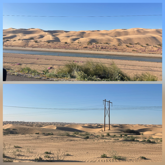
The surprise of this drive was the Imperial Sand Dunes. I read something about seeing some sand dunes, but these were much larger and expansive than I expected AND included the All-American Canal - primary water source flowing through the Imperial Valley running directly along and across the southern edge of the dunes.
So, our 5-hour drive was, as we always hope, filled with fun and oddities.
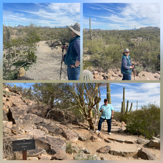
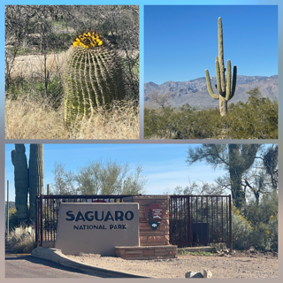
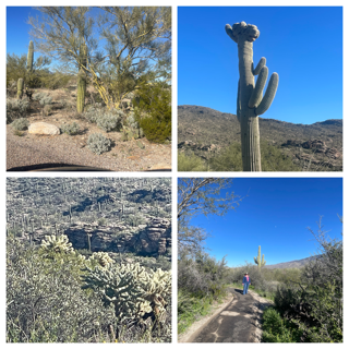
Day 8 – Wednesday – Today we went to Saguaro National Park – West. We were excited to find out if we could see a difference between the East and West districts. Yes, for sure! Today’s West district had many more Saguaros, but they were generally smaller. Also, the East gets about 20% more rain – sound like a lot, right? Well, sort of. West get around 10 inches while east gets 12 inches a year. Thus, the east district is noticeably greener. The west district was more “brown” and seemed more like the desert we expected. Not sure either of us could pick a favorite. Today we drove the 6-mile, Bajada Loop (well-maintained dirt road). While yesterday’s loop road was much smoother, today it felt like driving through the desert.
We hiked the Signal Hill hike which, while not very long, it was all up and down, crossing a dry river bed and at the top, a panoramic view AND dozens of petroglyphs carved on the surface of the grey and brown rocks, dating from the Hohokam period that peaked in the 13th and 14th centuries. The views were incredible and we saw lots of insects (flies, grasshoppers, ants and several different colors of butterflies), mammals (2 ground squirrels) and several birds.

Today’s weather was 68 and about as perfect as you could want. After the park visit, we went into Tucson to check out the Barrio Viejo district, known for its vibrant, colorful adobe row houses and traditional Mexican American culture.
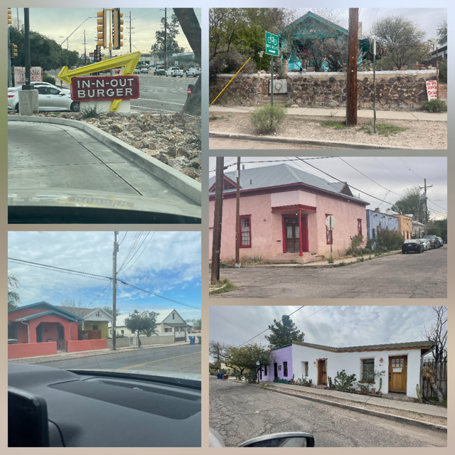
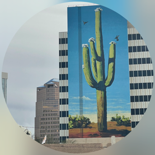
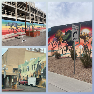
After the Barrio, we went to the El Presidio Historic District: The site of the original 1775 Spanish fort, featuring adobe homes, the Tucson Museum of Art, and the Presidio San Agustin del Tucson. Downtown was very nice with some incredible murals. Including Arizona’s tallest, 15 stories, mural of a cactus.
From downtown we drove the Miracle Mile Historic District: described as a significant post-WWII commercial corridor that was a major route (U.S. Routes 80/89) into the city. MORE Importantly, we saw and went to IN-N-OUT Burger for lunch. Chris has a grilled cheese and I had a double – double animal burger and we shared animal fries. If all of this seems like a foreign language, you need to look up the restaurant as it has a cult following. I used to get lunch there sometimes when I worked in CA. To finish off our Tucson day, we did laundry. Woo Hoo!
Couple of things to get caught up on: When we drove in to Bisbee a couple of days ago, we went over the 2,000 miles drive on this trip. Outside of Tombstone, we saw 1 nice white tail buck along the road and shortly after, saw 2 more white tails.
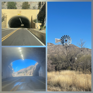
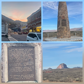
Day 7 – Tuesday - The morning began with us driving about 45 min to Tombstone AZ. It was scenic and even included a tunnel through Mule Pass.
I know this won’t surprise you but we were a bit ahead of schedule so when we arrived many of the stores weren’t open yet. Which was okay because it was quite cool walking the streets with the feeling of the wild west. It felt like we were on set of Gunsmoke with gunslingers, a stagecoach, and even the OK Corral. It was too early to enter a saloon, but we did stop and get a “cowboy coffee” while we waited for the Rose Tree museum to open. Not a fan of coffee, only Chris had a cup and mentioned it was quite strong. We didn’t get a chance to see the World’s Largest Rose Tree ☹because it never actually opened and we always have things to do and see - like visiting Boot Hill.
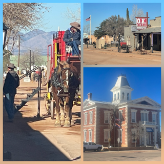
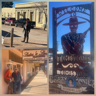
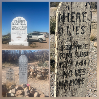
Chris asked, hadn’t we already visited a “Boot Hill”? And while the answer to that question was yes, it wasn’t the authentic one. This one was the real Boot Hill, our third to be exact. How many people have seen the boot hills of Deadwood SD, Dodge City, KS and Tombstone, AZ? Jealous? With graves and epitaphs of people who lived in Tombstone over 150 years ago including some who died in the famous OK Corral.
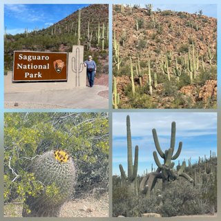
From Tombstone we drove to Saguaro National Park - Rincon/East, making it our 39th National Park and 3rd of the trip. Saguaro is made up of two distinct districts, the Mountain (dryer) and the Rincon (wetter and greener). It was spectacular! We drove the scenic loop with many vistas and did a hike and, ready for this, we were hot! I was wearing a long-sleeved shirt and suddenly it was 67 degrees with beautiful blue skies. After all the weather we have experienced, today sort of caught us by surprise. Tomorrow is supposed to be 72. Shorts! I really enjoyed seeing the giant Saguaro’s (biggest are around 150 years old) and seeing that all those cactus’s I drew as a little kid, were close. Okay, I think mine always looked like a person with 2 arms and these consistently had many more than just 2 “arms”. But, hey, I was a kid! Lots of pictures follow.
We drove to our hotel, where we are staying 2 nights for the first time on this trip, but not before stopping at Costco for a few items. 😊 The plan for tomorrow is supposed to be a nice laid-back day, we will see.
Day 6 – Monday – We woke up to our first day in a while without a storm watch/warning. Of course, there was a “Ice Fog” alert but it expired at 9:00 am so we are not counting that! Our first stop was White Sands National Park; 2nd park on this trip so far. Luckily, we visited this park 2 years ago so when we arrived and the Ranger said they could not open the gate because of the remaining Ice Fog / conditions, it didn’t hurt as bad to just keep going and not wait until the park opened.
Yes, while the alert expired at 9:00, we were driving for the first 45 minute in fog (never really seemed icy at all), but we could see at least ¼ mile down the road. It was strange, it would seem like a fog bank was coming and by the time we got to it, it would have moved. Basically, the morning sun was burning off just ahead of us. Very convenient. In less than an hour, it was gone completely.
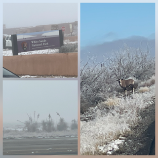
Antelope! WAIT, was it an African Oryx (Gemsbok)? As we drove through the White Sands Missile Range, we spotted a very big pronghorn antelope along the road. Well, we THOUGHT it was a big pronghorn antelope, but when we looked on the web tonight, we learned that that it was actually an AFRICAN ORYX!! Take that Newfound and its Moose! Notice the black face of the Oryx. 50 to 100 were released around 1970 and the population has grown. Later in the trip we would see many hawks, a giant roadrunner, and a gorilla in the back of a pickup.

Trains update: 😊 As we drove west on I-10, the railroad was parallel to us and the BIG trains were out today. First one we saw had 4 engines in front and 2 more in the middle and was over 3 miles long! We saw 3 more trains over the next 90 minutes with the average length of each well over 2 miles.
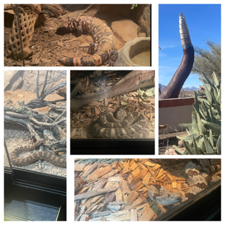
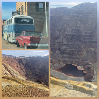
As we drove to Bisbee, AZ (5 hr.) we not only left the fog behind, we left all signs of snow behind too! We stopped and visited the Chiricahua Desert Museum. It was small but had a collection of over 50 different venomous reptiles (rattlesnakes and Gila Monsters). Even though the snakes were safely behind glass, Chris and I laughed at catching each other trying to “sneak” up on the glass – as if the snake could jump out an get us! 😊
Outside Douglas NM we saw the Geronimo Surrender Monument (built 1934) and then in Douglas we drove up to the border of Mexico just to see what the wall looked like.
Bisbee was better than I expected. It is an old copper mining town which has survived and prospered now as a vacation / shopping area – utilizing all the original downtown buildings and having lots of artists, antiques, etc.
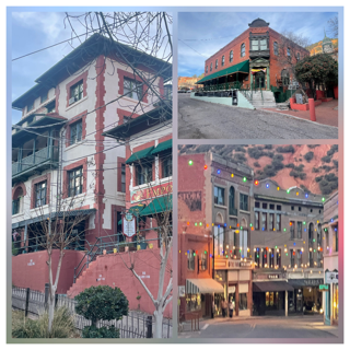
Just outside of town the road drives along the rim of a old open pit mine (1 mile across, 800 feet deep, incredibly colorful down the sides because of its mineral content).
Day 5 – Sunday - The storm got extended until 11 AM but we didn’t experience any issues. The roads weren’t snow free, but at least one lane was clear and there was hardly any traffic. For example, we drove 40 miles and never saw ONE vehicle going south (same as us) on the road. Not in front of us, not behind us! Lots of semi’s coming north on the road but I don’t think I have ever driven so far and not seen another vehicle going in my direction. We made the right choice to stay in Santa Rosa last night. We saw 1 semi-trailer that had burned up (MAYBE last night) and one Amazon Prime semi that was in the ditch that was definitely from last night as there were 6 or 7 people trying to unload all the boxes!
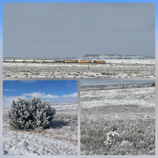
Today was all about the landscape. Everything was covered in snow and ice. Breathtaking! We saw a surprising amount of wildlife: hawks; doves; swallows; 1 road runner and even a couple of COYOTES. One hawk was in mid-flight, and we could see its red tail feathers. We also saw an Elk crossing sign (but this will surprise you, we did not see an elk!). Lots of black cattle though.
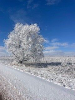
We started the drive with snow and what we originally thought was ice in all the trees and bushes. However, as we kept remarking on it, we realized it either wasn’t ice or it is different than what we get in MI. As you can see, the “ice” was solid white. Gorgeous!
We drove through Vaughn, NM – the intersection of the Burlington Northern Santa Fe and Union Pacific railroad lines! So, we had train track and trains paralleling our road nearly the whole 3 hours. We saw a few trains, but the biggest one was so big (How big was it?!?), it had SIX Engines in the front and then about ½ back, it had TWO more engines! The highlight of the trains though was looking out over the snowy high plains and seeing one BNSF engine going very fast all by itself down the track! No picture as it was really moving (and in the opposite direction as us) so it came and went fast.
Along the way, we went to the State Park, Valley of the Fire. It is a large valley where a lava flow occurred 5,000 years ago and to this day, still looks like as black as the day it existed. Of course, our pictures aren’t as “black” as they should be because it was covered in snow. 😊
We are used to seeing 3 trailers behind a semi in some states. But, today, we saw something new. 1 car pulling 2 other cars! Does it surprise you that we saw (again!) the World’s largest Pistachio. Who would think we could see such a thing twice in 2 years?
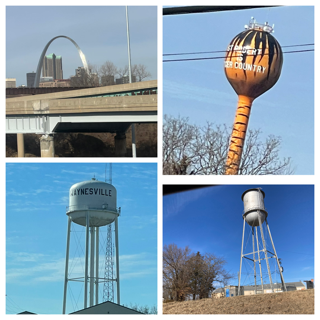
While it is only OUR opinion, we think we found in Alamogordo the World’s Shortest water tower!
Tomorrow is supposed to be SUNNY with ZERO weather alerts at this point. WOO HOO!
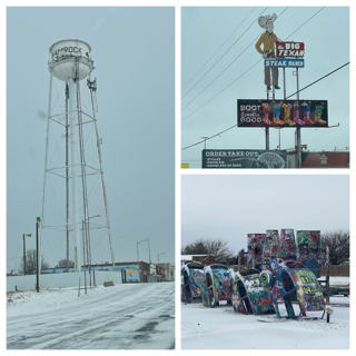
Day 4 – Saturday – We went to bed last night with the temperature dropping and snow falling and with no reason to set an alarm, so we slept in, 8:00! 😊 We looked outside and were pleasantly surprised, it didn’t look too hazardous for us Michiganders. Expecting 6 inches and up with snow still falling but it looked more like 2 inches with some snow falling. We checked the different weather and travel sites, and they showed that getting to Tucumcari or Santa Rosa New Mexico would be slower than usual but not crazy bad. Instead of 3- or 4-hour drive, it would be more like 4 or 5 hours. That said, it was crazy cold. As we left the motel, it was 4 degrees and felt like -14! We packed up and left the motel in Shamrock around 9:30 but before we entered I-40, we needed to go to downtown Shamrock and see the tallest water tower in Texas. It was very tall.
Some background on this trip. We rented an intermediate SUV for the drive with the plan of getting a 4WD or AWD. The reason that was important is on the way home we plan on driving through CO (and other mountainous states) and, at times, they only allow vehicles with chains on their tires or 4WD or AWD. When I went to pick up our rental, of course, all they had were front wheel drive. I explained that I had a 1-month rental and planned to drive across country and needed 4WD or AWD. I told them no hurry, I had plenty of time to wait if they would just be so kind as to check their inventory. They were very nice and made some calls and struck out. I told them I appreciated their effort but if they didn’t mind, I had lots of time and wanted to wait a while and hoped something would come up. 30 minutes later a person returned a Mazda CX-5, AWD!!! Given the current situation, that wait was worth every minute. 😊 Added bonus? Same make and model we drove 9,000+ miles around Canada in a few months ago.
The drive went very well and it was surprisingly pretty as the snow seemed to change the view into a black & white landscape. We had 1 very clear lane for almost the entire drive. We stopped at our first Buc-ees for lunch, perfect as always. Instead of seeing the Cadillac Ranch (1/2 buried and graffiti Cadillacs) that we saw 2 years ago, this time we went to a parody location, Slug Bug Ranch!
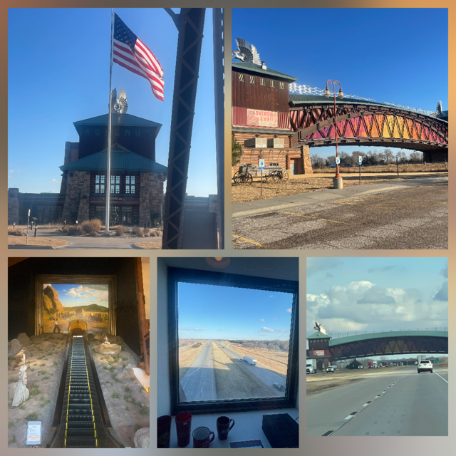
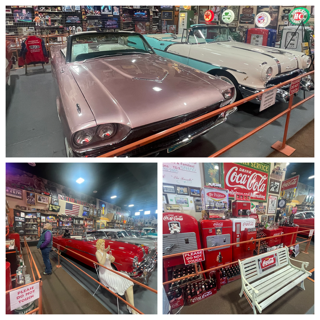
Last time we traveled this route, we missed the Russel Truck Stop – a “famous” Truckstop with its own, free, auto museum. Given we had lots of time, we were not going to miss it again. As we pulled into the lot, I was sure we were in the wrong place. Turns out they have completely built a new site so the pictures on the web generally are of the original. Luckily, I figured that out before we drove away. It IS a classic truck stop, the car museum is first rate! Next, we pulled off to see the World’s Largest Flip-Flop. Hey, a little snow can’t keep us from the World's Largest Flip-Flop! 😊

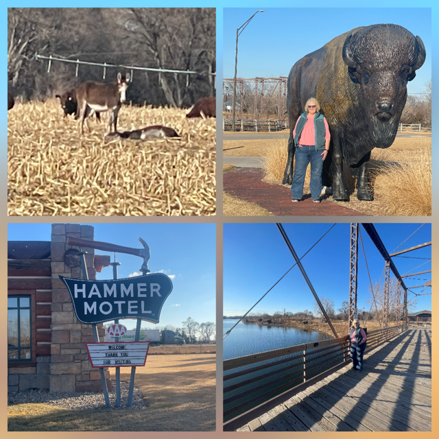
We arrived in Tucumcari and were very impressed with the number of Route 66 stops and the town itself.
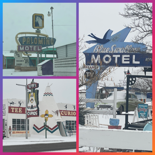
Since we picked up an hour as we entered New Mexico (Mountain Time) and the roads were still looking “good”. We decided to push on to Santa Rosa, another Route 66 town. Sadly, it does not have many Route 66 locations but it is home to the “famous” Blue Hole! A natural sinkhole that's cylindrical with a bell-shaped widening at the bottom. 80 feet deep, crystal clear with high visibility, always around 61 degrees Fahrenheit. We watched the steam rising from the surface.
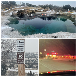
Bad news, we saw our first "Watch out for snakes" sign today. Good news, it is WAY to cold to worry about snakes.
Given our success today, we are still a little ahead of schedule. Tomorrow, instead of having a 7+ hour drive to Alamogordo, we should only have a 3 hour, assuming the weather cooperates. Currently the winter storm warning in this area expires tomorrow morning at 8:00 am. Fingers crossed!
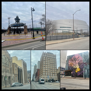
Day 3 – Friday – We left Joplin early in the morning to get to Tulsa when the Woody Guthrie museum opened. As it turned out, we were early enough to have time to crisscross downtown Tulsa (yes, it looks just like it does in Tulsa King – but we never saw Sylvester Stallone!). Tulsa’s downtown is very nice. We saw the Greenwood Rising, Black Wall Street Museum, a very nice minor league baseball stadium, their downtown sports arena, and some excellent architecture and murals. As we arrived at Woody’s, we were still 30 minutes early and an idea popped into our heads. Given the massive blizzard coming our way, instead of staying in OKC tonight as we had just rearranged last night, we decided the best way to take on a blizzard is straight into its teeth. We decided to skip the museums (sorry Woody and Bob) and get to OKC and the Museum of Art (MOA) and the Chihuly exhibit and then use our extra time to drive straight into the oncoming blizzard like kamikaze! Okay, not EXACTLY like kamikaze, we would not die trying, we would get off the expressway at the first sign of snow and hunker down at a motel and see what tomorrow (Saturday) brings us. 😊
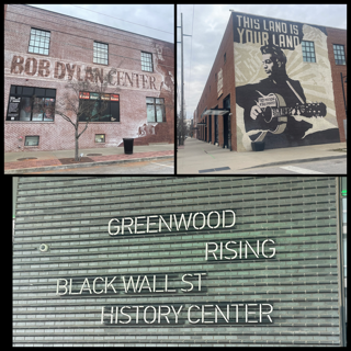
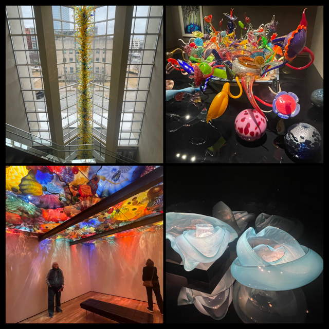
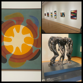
OKC was impressive. The Chihuly exhibit was everything we hoped it would be. I have been trying to get Chris to the Seattle Chihuly museum for a few years, so I am thrilled that, while not Seattle, this exhibit was truly impressive. In addition, they had a special exhibition on Paul Reed (who we never heard of but it was great).
What is the BIG advantage of traveling with an imminent blizzard AND on a Friday? It seemed like we were the only people driving around downtown Tulsa and OKC. Traffic was non-existent. We arrived at the MOA at 11:30 and yet we found a parking spot DIRECTLY in front of the museum! We drove around downtown OKC, visited Bricktown, drove Route 66 and walked through Plaza Walls (many murals, like Wynwood Walls in Miami).
As we left OKC, we looked at the forecast for precipitation and saw that we should be able to get to Shamrock TX about 1 or 2 hours ahead of the storm (3-hour drive). While we were watching the weather, we still had time to exit at Weatherford (Space City on Route 66) and saw their giant astronaut along 66. We also saw buffalo, but sadly no moose and we finished our first audio book for this trip, “The Heaven & Earth Grocery Store”. Good book and just so happened to be on Chris’s book club assignment so a win-win. It was interesting see snow plows sitting on many different exits, staged for tonight.
As we arrived in Shamrock, it started to mist. Timing baby!!! We are in the room I had reserved for tomorrow night (Saturday) so we are officially 1 day AHEAD of schedule now. Tomorrow? Originally, our destination was Alamogordo, NM (6 hours) but since we are a day ahead, hopefully the roads will be okay enough for us to make it down the highway 2 or 3 hours (thus cutting the 6-hour drive into two, 3-hour drives). Worse case, we will stay in Shamrock and hopefully leave Sunday, back on our original schedule. We shall see!
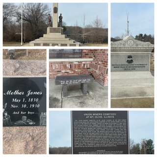
Day 2 – Thursday – We left Springfield, IL at 9:00 on the button with sunny skies and a great forecast for the day. One of our first stops of the day turned out to be the Mother Jones Monument. We had no idea this monument even existed and were pleasantly surprised to learn a bit of history. The drive to St. Louis went well with lots of sunshine providing us with a sunny reflecting view of the Arch, the 1st National Park we saw on this trip. We didn’t stop because we had been to the Arch before.
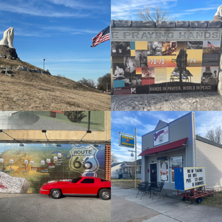
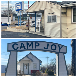
The drive today was about 5.5 hours so with the extra time we visited Route 66 towns of Waynesville and Lebanon where we saw an original Stagecoach stop (you might say the first “route 66”), one of the original motels on the ‘mother road”, several murals, and an original cabin from Camp Joy.
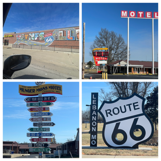
Once we arrived in Joplin we went to the Route 66 mural park, saw 32-foot-tall giant hands praying for peace and a “famous” ice cream stop which also houses a Superman Museum (sadly It was closed, but still fun to see).
As we were driving, we discovered we were going to be driving by a Buc-ees so we were planning to stop for lunch. Unfortunately, as we were approaching the exit there was some sort of fire in the area (large grass fire?) which covered about 3 miles of the expressway with smoke, so it didn’t make any sense with Chris’s asthma to stop and walk around. Oh well, there will be more Buc-ees!
If you haven’t heard, there is, according to CNN, “A potentially historic winter storm” winding up across the south and it has the nerve to be in OUR WAY!! But fear not, we are nothing if not adaptable. Tomorrow (Friday) we WERE supposed to drive 1.5 hours to Tulsa and then see the Bob Dylan and Woody Guthrie museums and the site of “Black Wallstreet” – the Tulsa race riots and spend the night in Tulsa. Getting up Saturday and driving 1.5 hours to OKC to visit the OKC Museum of Art Chihuly glass exhibit and then drive to the Texas border (2.5 hours). NOW, with the storm expected to move in early evening on Friday, we have cancelled our Friday night stay in Tulsa and will get up tomorrow morning early so we can still go to the Woody Guthrie (sorry Bob D!) museum and then head to OKC and in the afternoon to visit the Chihuly exhibit. This frees up Saturday to either spend most of the day getting to the Texas border or, if the weather is too nasty, we will spend another night in OKC. We really are getting our kicks on 66!
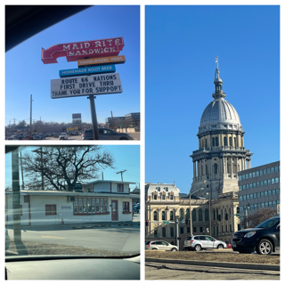
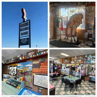
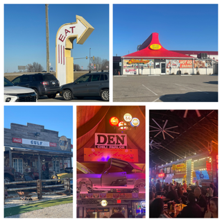
Day 1 – Wednesday – Originally, we planned on leaving on Thursday to drive to Springfield MO as Chris had a meeting Wednesday evening which she needed to attend in person. As we got closer to leaving, Chris verified the meeting would be on Zoom and I verified that a 30-day car rental is $2 more than a 28-day rental so, boom, we left today instead. Leaving early provide us with the opportunity to be less aggressive with our first day of driving - target: Springfield IL (ironically same name, different state). The advantage of leaving today was instead of doing a 9-hour drive and hoping the weather cooperated, we only have to do a 5+ hour drive today and tomorrow we should be able to do another 5+ and get to Joplin, MO. Leaving Grand Rapids the weather was only so so with a Winter Storm Warning. We were pretty confident once we left MI the roads would be fine. While the roads were snow covered and mostly 2 tracks on the expressway, we drove about 35 mph for nearly 3 hours and eventually drove right out of it. Normally that same stretch of highway would take less than 1.5 hours. Along the way, we saw 4 spin offs (3 cars, 1 18-wheel tanker truck), and as we entered I-94 West, we saw they had I-94 east closed. By the time we reached Illinois, the sun was out and roads were dry and an hour south of Chicago, the snow was gone. Today and tomorrow are all about safely getting out of Michigan and near Oklahoma. That said, we still know how to have a good time and Springfield, IL has the most Route 66 locations and museums everywhere. Thus, we drove through downtown, saw the Capital and visited the Maid Rite Sandwich Shop (First drive through restaurant in the USA), Cozy Dog Drive In (family owned since 1946), and Motorheads Bar & Grill (Located in an Old Stuckey’s with MANY additions to it and home to the most Route 66 signs in the world). I enjoyed my Corn dog at Cozy Dog and after Chris’s meeting we went to Motorheads for a surprisingly good dinner. Weather forecast for tomorrow is good but, after that, OK and TX might be a little fun. Pictures to come tomorrow.